Papillion, Nebraska to Rapid City, South Dakota 

I got up at 7 AM Monday morning, May 30, 2005 --Memorial Day. . I knew I'd be pushing it sleeping that late, but I figured if we got right on the road we'd be fine. We didn't. Zack was very sleepy, having stayed up all night watching anime, and it took several tries to get him up. Every time I turned around, there was one more thing to hang us up. I'd hoped to get started by 8 AM, but we didn't finally get out on the road until 9:25. I knew we'd be cutting it close. We had miles to go before that evening.

We had to get back on Interstate 29 headed north, but I didn't want to go through Belleview again. From Papillion, we took Highway 75 north to Interstate 80 east, which took us to I-29. We crossed the Missouri River again into Council Bluffs, Iowa, where we headed north towards Souix City. From then on, I had Satori going as fast as she could go. It was a chilly morning, with some light sprinkles. We passed LeMars, Iowa, "Ice Cream Capital of the World." The road ran past miles and miles of farmland. Interstate 29 is part of the Lewis & Clark Trail, commemorating the expedition of discovery which traveled through the area in 1804. Sergeant Charles Floyd was the only member of the expedition to die during the journey, some think of a burst appendix. He was buried atop a bluff overlooking the Missouri River. The highway runs right past his grave, which is marked by a 100-foot oblisk just off Exit 113 near Souix City. The oblisk is recognized by the U.S. Department of the Interior as the United States' first National Historic Landmark.

I-29 followed the bend of the Missouri before pointing back north. At 11:10, we crossed a little bridge over a tiny creek, and suddenly we were in South Dakota. North Souix City even calls itself "The Gateway to South Dakota." We were 71 miles from Souix Falls. At exit 18, on the west side of the highway, were four concrete monkeys, standing enigmatically alongside the fence. I have no idea what they were about.
 
We were barely 30 miles into South Dakota when I saw my first Wall Drug sign. Every 10 miles or so, the whole trip across South Dakota, we'd pass a Wall Drug sign. Some looked like they'd been there for years, maybe decades.  

The highway led us into some cheerful rolling hills. The view to the west was speckled blue and grey, but it looked like some dark clouds were moving in. At the Irene exit, I saw a sign that said it was 65 degrees out. Blue skies peeked through the clouds as we approached Souix Falls, and we found a convenience store for a pit stop. 

At 12:44, we left the civilization of Souix Falls and headed west on Interstate 90, westward ho. It seemed like time was not on our side. We should have started much earlier. The blue skies seemed to skitter away, and only a grey haze faced us to the west. At Exit 374, we passed a giant bull's head off to the side of the road. I figured it marked somebody's ranch. Ranching, hunting, fishing and the fur trade are major parts of South Dakota's economy, leaving animal activists a tough room to play in the state. In fact, I saw billboards declaring specifically that animal rights activists are not welcome in South Dakota.

Interstate 90, westbound near Souix Falls
Eastern South Dakota looks remarkably like western South Dakota --at least until you get to the Badlands and the Black Hills. The road literally looks like this for hundreds of miles. The drive isn't as much boring as it is hypnotizing. The repetition of mile after mile after mile of never-changing landscape can have a numbing effect on the senses. Luckily, there always seemed to be a Wall Drug sign every few miles or so to wake people up.
 
We passed another billboard for a truck service, offering "24-Hour Toe Service." I think I've been to that website... At Exit 350, we passed De Smet, South Dakota, county seat of Kingsbury County and the home of Laura Ingalls Wilder, the author of the "Little House on the Prairie" books. At 1:43, we pulled into Mitchell, where I was finally going to see the Corn Palace. When we lived in Belle Fourche in 1968, I'd see tourist pamphlets on the state. They'd list all the places to see in the Black Hills... and the Corn Palace in Mitchell. We never got to Mitchell when I was a kid, so I figured this might be my only chance to see it.
The Mitchell Corn Palace
 
Highway signs leading up to Mitchell set the mood: "It's a MAIZE-ing!" "You're almost EAR!" Getting off the highway, more signs took us past the Middle Border Museum and into town.  

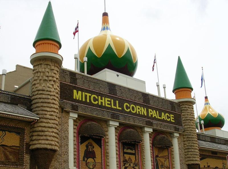
The first Corn Palace was built in 1892 as a showcase for all the crops grown in the area around Mitchell. It was also a slap back at Lewis & Clark, who wrote in their famous journals that nobody could ever make a living farming in that area. The idea took hold and grew, and there has been a Corn Palace in Mitchell ever since. Every year, thousands of bushels of corn and grain are used to decorate the Palace, which attracts a half million visitors each year.  

Inside, the Corn Palace is an autitorium. There's a stage on one end, but with a flat area directly in front big enough for a basketball court. When we were there, the court was taken over by a gigantic gift shop, but dozens of basketball games are played there every years by area schools. Zack and I got some souveniers and a crushed penny. The exterior is decorated with clever murals made of corn husks-- some very elaborate. The designs change every year.  

There was a monument across the street to Oscar Howe, the artist who made the exterior murals for decades. The main street has many 19-century buildings and is full of little shops and restaurants. One place was selling moon pie-type treats called "cow patties." Um, no thanks. We took some more pictures and hit the road. Time was marching on. It started to sprinkle again. 

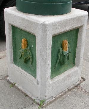
Detail of Mitchell Streetlamp
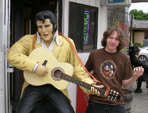
Zack with "the King," downtown Mitchell
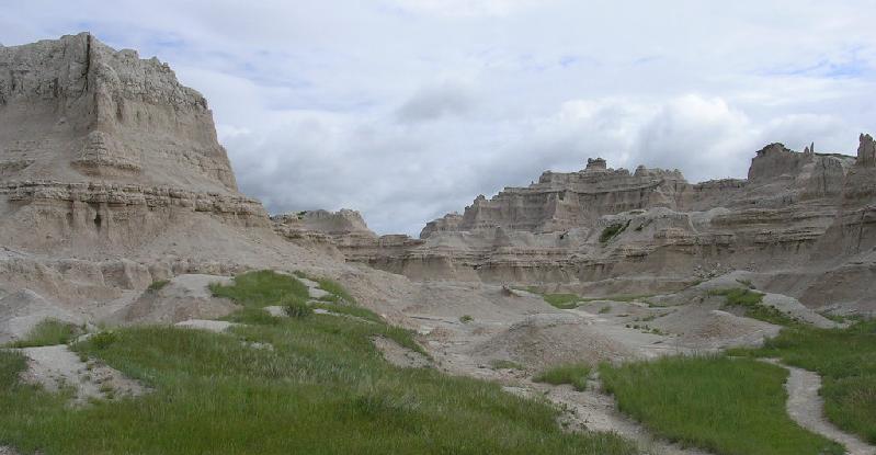
Back on the interstate, Zack scanned for some music on the radio, and found three Christian radio stations in a row. A billboard advertising a museum teased "Discover Mt. Rushmore's Mormon Connection!" The landscape stretched off in all directions, with few hills to break the monotony. The exception was the rugged hills around Lake Francis Case, just off Exit 323. The interstate finally took us back to the western side of the Missouri River. Velvety green hills surrounded the lake, and the road gracefully twisted around the curves in the land before heading straight west again. I saw some dark shapes on the northwest horizon and wondered if they might be the Black Hills, but we were much too far away. At 3:47, some road construction slowed us down near Exit 235.
 
There was an impressive mountain vista near Mile Marker 174, but even that couldn't cheer me up. The dark clouds overhead reflected my mood. It was getting late in the day, sunset was coming, and I didn't think we'd make it to the Badlands in time. Down the road, however, we passed a sign: "Now Entering Mountain Time Zone." Zack announced that made it an hour earlier. Instead of 4:42, it was only 3:42. We'd be able to make it to the Badlands on time! I said, "Zack, you're a genius!" "Yes, that's correct," he replied (imitating Bucky from the comic strip Get Fuzzy). No matter how late we were, we were still an hour early. 
At Exit 170, we passed 1880 Town, a recreation of a 19-century pioneer town assembled with authentic period buildings. Several movies, including part of "Dances With Wolves," have been filmed there. We laughed at a sculpture near the exit: a life-sized dinosaur led on a leash by a caveman, all made from used car parts. Ominous clouds loomed ahead. The air turned very cool, signaling that it was raining somewhere. At Exit 150, we passed the turnoff for the Pine Ridge Reservation. We got off the interstate at Exit 131 and headed south on Highway 240. It was just a short jog to Badlands National Park. I was afraid the clouds and the rain would spoil the stark beauty of the park. Instead, the rolling clouds only served to enhance the unreal, unearthly feel of the place.
Zack and I stopped at the Big Badlands Overlook and walked around, taking pictures. There were lots of people there, but it didn't seem crowded at all. Down the park road, there were a couple of harrowing curves before we got to the visitor's center. The center itself was closed for remodeling, but the Cedar Pass Lodge next door was open. We got some souvenirs. I couldn't believe it was still light out. From there, we traveled down the Badlands Loop Road, stopping here and there to marvel at the bizzare views.
At the Pinnacles Entrance, we followed 240 back out of the park. That was where Zack and I saw the deer, standing at the fence near the road. He was so still, I thought he was a lawn decoration, but then he bolted and ran back towards the cover of a creekbed.
 
The road took us up to the town of Wall, where I had the chance to take Zack to one of South Dakota's landmarks: Wall Drug. Back when driving was a novelty, the drug store in Wall had an idea: advertise with signs all over the country. There'd be signs saying "100 miles to Wall Drug" followed by "90 miles to Wall Drug" and so on. The big draw was "free ice water!" I remember stopping at Wall Drug when I was a kid. There were statues of dinosaurs and a model of Mt. Rushmore to have your picture taken next to. And the ice water was really cold, served in a little paper cup.  

When Zack and I pulled into Wall, we didn't have any trouble finding it. The business had expanded so much that it's more like Wall Mall. It's not just one store any more but a block of stores, selling everything from clothing to jewelry to ammunition. Wall Drug has art galleries, collectibles, sculptures, and even... prescription drugs. Wall Drug has a little bit of everything. It even has a chapel. There's casinos across the street, and a Lutheran church right next door. We got some souvenirs and moved on.  


Me, at Wall Drug
Right about that time it really started to rain. At Exit 78 we saw a sign for Steve's, "The world's smallest biker bar." Sturgis, where they have a huge motorcycle rally every year, was not far away. When we topped a hill several miles west of there, that's when the Black Hills came into view. At 7:20 Mountain time, we pulled into Rapid City. After checking into our motel, we ate supper at the Burger King across the highway. It was wet and cold out. The TV weather was predicting more rain for the next day, with a high of only 56 degrees. Still, my mood was good. Rain or shine, hot or cold, we were back in the Black Hills, and I felt at peace. We crashed a little before 10. That day, Zack and I drove 561 miles from Papillion to Rapid City.
 
 
Internet Links:
Lewis & Clark
Sergeant Floyd Memorial
The Corn Palace
Badlands National Park
Wall Drug
The Laura Ingalls Wilder Memorial Society
 
All content copyright (c)2005 by Tim & Zack Frayser