 Scottsbluff,
Nebraska to Papillion, Nebraska... and back home
Scottsbluff,
Nebraska to Papillion, Nebraska... and back home
At 3 AM Wednesday morning, June 1st, I was
up: the room was hot. I turned up the air conditioner and went back to
bed, but didn't fall back asleep until 4. I was up again at 7 AM local
time. I figure I got about 9 hours of sleep. The continental breakfast
downstairs was pretty good: cereal, bagels, fruit, juice, and waffels to
order. Zack went downstairs to eat while I started packing. For $58 a night,
it wasn't a bad deal at all. We left the Super 8 Motel just before 9:30
local time, and promptly got lost trying to get out of town. All the streets
were at weird angles. Luckily, we finally did find the restaurants-- they
were all on 27th Street. Highway 92 took us out of town, past the Farm
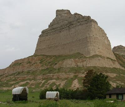
and Ranch Museum, and out to Scott's Bluff.
I hadn't planned on us staying too
long, but there was a lot more to look at than I'd imagined. For hundreds
of years, Native Americans passed by as they hunted the massive herds of
buffalo. Explorers took note of the bluffs as they first began mapping
the area. Scott's Bluff was a landmark for thousands of people making their
way west. Between 1840 and 1869, perhaps half a million people fell under
the shadows of the bluffs.
One can only imagine the experience of the pioneers heading
for the Oregon Territory. After weeks of seeing only flat, featureless
prairie, it must have been amazing to see those bluffs suddenly rise up
on the horizon. Scott's Bluff is still very impressive. |
|
After looking through the visitor's center we took a walk
out past the covered wagons out front. When the Oregon Trail settlers came
through there in the early 1800's they had to travel through Mitchell Pass.
The pass was so narrow at one point that the wagons had to go in single
file. The passage of thousands of wagons left a mark in the land that was
still visible. The track was barely wide enough for a Volkswagen to squeeze
through. It was humbling to think of whole families, carrying everything
they owned on one little wagon, all their hopes and dreams, squeezing their
way down that narrow trail headed towards a new life on the west coast.
A modern family was ahead of us, taking pictures. Their son Alex had wandered
up ahead out of sight. The mother cried out, "Alex!" and was shocked when
her own voice came booming back at her. She didn't know Mitchell Pass had
an echo.
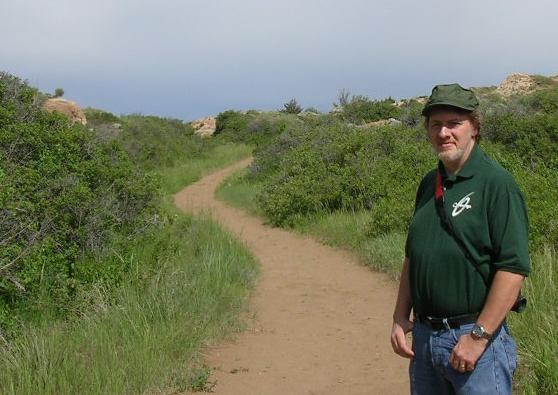 Me, at Mitchell Pass on the Oregon Trail
Far up the trail, a kid came running past us back towards
his family and disappeared behind us. We made our way back to the car,
and on a lark thought we'd take the road up to the top of the bluff. I
hadn't really planned on going all the way, but when the road turned an
angle I hadn't expected I got curious. Ahead was a tunnel-- the first of
three. The bluffs were so steep that tunnels had to be cut into the sides
to allow traffic up to the top. The view was incredible! The wind wasn't
bad at all, and Zack found a rabbit next to the trail. He let us get within
just a few feet of him before hopping off into the bush. We could see the
whole countryside from up there. In fact, way off to the southeast, I could
make out the needlepoint of Chimney Rock, our next stop.
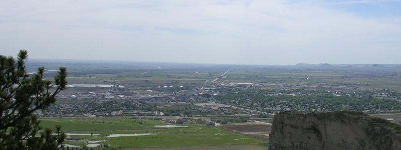 The view from atop Scott's Bluff
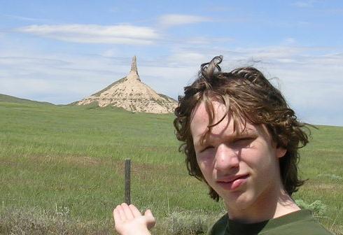 Zack at Chimney Rock
|
We came down the narrow road off the
bluff and followed Highway 92 back through town. There were no signs that
I could see, so it was only by sheer luck that we were on the right path.
The highway led us north through town, and turned east at the railroad
tracks. I didn't see any signs until we were miles down the road, by which
point I could clearly see Chimney Rock straight ahead. Still, the turnoff
was not clearly marked, and we had to turn around to find the little road
out to the visitor's center. The little museum is privately owned, so it
was a $3 fee to get inside.
Chimney Rock had a small but sincere little museum; it
seemed like a lot of love went into keeping it going. We took some pictures,
watched part of the movie in the theater, then got back on the highway. |
Highway 92 linked up with Highway 26, which would take us
all the way to Oglalla. The next town down the road was Bridgeport, population
1,594. The road jogged north around the town, which was where we linked
up with Highway 385 again briefly. A bridge took us over a wet smudge in
the landscape a sign told us was the North Platte River. A bigger bridge
took us over the railroad tracks, and then we were headed southeast again
on Highway 26. That was where we passed a man driving a horse-drawn covered
wagon, making his own journey down the Oregon Trail. He waved at us. It
was on the road to Broadwater that the wind really picked up. There's not
a lot around the Nebraska landscape to slow down the wind, and it was pretty
fierce. The gas tank was getting kind of low, so I decided to stop in the
next town for $5 of gas. The next town was the little farming community
of Lisco, Nebraska. We pulled into the Lisco Superette, the only store
in town (their motto: "Sorry, no Credit Cards"), where I got some gas from
the 1970's-era pump. The people I saw were lean and proud, carrying on
the fiercely independent spirit of the pioneers that first settled western
Nebraska. The tall, metal grain silo across the street had an assortment
of pipes on the roof that whistled and howled in the relentless wind. The
noise never stopped. It got louder, or softer, but never stopped. It was
like something from a Steven King novel. The Superette was run by a blonde
lady who almost charged me for a loaf of bread on the counter. "Whose is
this? Oh wait!" she said, "It's mine!"
Down the road, a hawk hunting along the shoulder swooped
mere feet past the van, a wingtip waving in greeting. There was some road
construction west of Oshkosh that slowed us down. A new bridge over the
railroad tracks was being built. Twin railroad tracks followed the road
east of Scottsbluff. Every few minutes, a train would pass by, dozens of
cars full of coal. Minutes later, a train would pass going the opposite
direction, pulling dozens of empty coal cars. We crossed the tracks and
entered Oshkosh ("Two Cool Museums"), population 1,060... or, if you were
traveling westbound, population 986. It made me wonder what happened to
those 74 people. There's probably a science fiction story there somewhere.
I finished the last of the peanuts I'd bought way back in Custer.
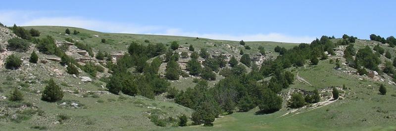 The hills at Ash Hollow
We traveled through the little town of Lewellen: "Small
Town, Big Heart." Big grain elevators, too. That was where the road turned
south briefly as it climbed the bluffs overlooking the North Platte River.
We climbed through the lovely, rocky, wooded hills of Ash Hollow State
Historical Park. The Oregon Trail went through Ash Hollow, where people
have been living since prehistoric times. Beyond a long, slow upgrade,
the road turned east and the landscape flattened out again. The crosswind
was merciless. We passed acres of farmland, and the wind made waves in
the oceans wheat before us. We passed farmers on lonely tractors, working
fields the size of small countries. At Mile Marker 126 we passed the turnoff
for Big Springs, not to be confused with my birthplace, Big Spring, Texas.
Highway 26 circles around the south of Lake McConaughy,
but we didn't glimpse it until Mile Marker 141. It was along this stretch
of road that Satori clicked over 140,000 miles. The road turned south to
Ogallala, winding past Searle Field of the Ogallala Municipal Airport,
and pulled into a BP gas station to top off the tank. A sign said it was
73 degrees out. At 1:18 local time, we pulled onto the 4-lane Interstate
80 for the long road back to Omaha. We'd been on 2-lane roads since leaving
Rapid City, 405 miles behind us. The speed limit on the interstate was
75, but Satori was doing good to reach 70. The interstate ran east to west,
and shadowed the bluffs overlooking the North Platte River. At 2:41, just
west of Mile Marker 150, we passed back into the Central Time Zone. About
25 minutes later, we rolled through the city of North Platte. I saw a Harley
Davidson dealership that had a service bay just for... Yamaha motorcycles?
They were either very open-minded Harley bikers, or that was the dump zone.
At Gothenburg, we pulled off the road. There were a couple
of things I wanted to see. We crossed the Cozad Canal. The town's motto:
"Grow With Us." In the town's charming little city park, we visited an
authentic Pony Express station. The route of the Pony Express came right
through the area, and back up the trail we had just traveled along the
North Platte River. Back near the interstate was the Sod House Museum.
Zack and I looked inside an authentic sod house, just like settlers used
to live in when they first came to Nebraska. The house looked bigger than
it really was. The interior wasn't much bigger than a two-stall restroom,
but it wasn't unusual for an entire family would live inside there. Outside
was a life-sized model of a buffalo, made entirely of barbed wire (four
miles worth, they said). Zack took my picture next to the World's Largest
Plow. For future reference, the Sod House Museum is just off the interstate
exit, behind the Shell station and across from the Pizza Hut.
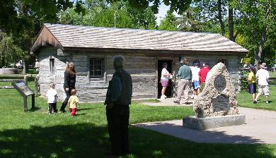 Pony Express Station, Gothenburg
|
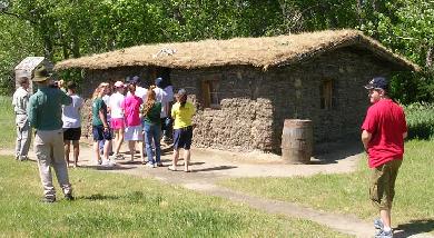 Sod House Museum
|
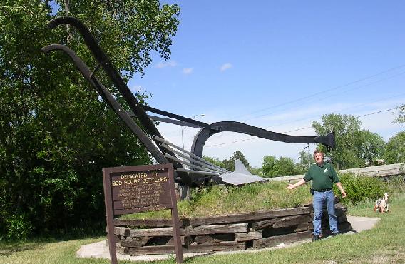 Me, at the World's Largest Plow
At 4:09 we left Gothenburg and headed back east on I-80.
Just west of Cozad, Zack saw a prayer written with spare tires spread out
across a hill alongside the highway. Visible from the highway right at
Exit 237 is the Heartland Museum of Military Vehicles. A long line of trucks,
tanks and transports face the highway. Next to the museum, on the other
side of a pond, is a little memorial. A Huey UH-1 army helicopter sits
on top of a short brick building. Alongside it, silhouettes of people in
anxious poses scramble up to the copter. This is the Memorial to the Fall
of Saigon, recreating the U.S. military's final, hasty departure from Vietnam.
I understand the museum even lights up the memorial at night.
Me, at the World's Largest Plow
At 4:09 we left Gothenburg and headed back east on I-80.
Just west of Cozad, Zack saw a prayer written with spare tires spread out
across a hill alongside the highway. Visible from the highway right at
Exit 237 is the Heartland Museum of Military Vehicles. A long line of trucks,
tanks and transports face the highway. Next to the museum, on the other
side of a pond, is a little memorial. A Huey UH-1 army helicopter sits
on top of a short brick building. Alongside it, silhouettes of people in
anxious poses scramble up to the copter. This is the Memorial to the Fall
of Saigon, recreating the U.S. military's final, hasty departure from Vietnam.
I understand the museum even lights up the memorial at night.
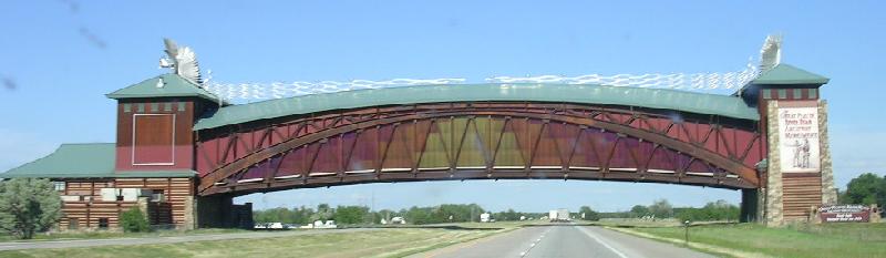 The Platte River Road Monument spans Interstate 80
We made one more stop in Kearney to visit the Great Platte
River Road Archway Monument. It's a museum and interactive multimedia center
dedicated to the exploration and settling of Nebraska. What makes it unusual
is that the monument spans over the width of Interstate 80. Nebraskans
are very proud of their history. It was already after 5 PM and near closing
time, so Zack and I didn't pay the $10 admission, but we did treat ourselves
to a buffalo burger in the snack bar. Outside was a mural, teepees, a maze
and an oversized stagecoach. Someone had put a Miss Piggy doll inside.
We headed east again right at 6 PM, passing right under the monument. At
6:45 we passed over Beaver Creek. We ended up passing over it four times
before going through the town of Beaver Crossing. At 6:56 we were still
60 miles from Lincoln, and the sun was starting to go down in the west.
While going through York, we passed a water tower that was painted to look
like a big, colorful hot air balloon. At 7:34, we passed the exit for Milford,
and off to the north of the highway I could see the World's Largest Covered
Wagon. It apparently used to be a tall gas station at one point. The wind
was pretty fierce, and I started to see warning signs: "Watch for Wind
on Overpass." I kept seeing tumbleweeds roll across the highway in front
of us. There were even wind socks mounted alongside the bridges, to give
drivers an idea of just how hard the wind was blowing. I didn't know how
many cars get blown off of Nebraska bridges every year, but I wasn't about
to be a statistic.
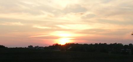
| We made Lincoln, Nebraska just before
8 PM. Interstate 80 circles the long way around Lincoln, and tall buildings
on the horizon were as close as we got to downtown. Less than an hour later,
as the last rays of the sun were disappearing in the west, we finally
rolled into Papillion. After some supper and checking my email, I went
on to bed. I didn't have any trouble falling asleep. Zack and I had traveled
469 miles that day.
In our three days on the road, Zack and I traveled 1,298
miles. |
 |
----------
The next morning, the three of us headed back to Oklahoma.
It was another 407 miles back to Broken Arrow. We pulled into our driveway
at 3:30 Thursday afternoon. Since leaving for the convention, I had driven
2,181 miles to the Black Hills and back. I'd traveled down roads new as
well as familiar... But, you know, as much as I enjoy traveling, the road
I like the best is the one that takes me home.
 Internet Links:
Scott's Bluff
Farm & Ranch Museum
Chimney Rock
The Oregon
Trail
The Heartland Museum
of Military Vehicles
Ash Hollow
Sod
House Museum & World's Largest Plow
The Pony Express
The Great Platte River Archway
Monument
World's
Largest Covered Wagon
Lake McConaughy
All content copyright (c)2005 by Tim & Zack
Frayser
Email: tapestry01@yahoo.com
BurningClam.Com
Internet Links:
Scott's Bluff
Farm & Ranch Museum
Chimney Rock
The Oregon
Trail
The Heartland Museum
of Military Vehicles
Ash Hollow
Sod
House Museum & World's Largest Plow
The Pony Express
The Great Platte River Archway
Monument
World's
Largest Covered Wagon
Lake McConaughy
All content copyright (c)2005 by Tim & Zack
Frayser
Email: tapestry01@yahoo.com
BurningClam.Com