The next morning, Wednesday, Aug. 27, I woke up at 6 AM and looked outside. It was still dark, and nobody was up. That was odd... until I realized I was in Nevada Pacific Time. It was really 4 AM. That meant I could go back to sleep for another 3 hours! So I did.
Before leaving for Burning Man, I researched the water situation. Everybody has to bring their own water to Burning Man. The web sites list several places to buy bottled water on the way to the playa, but I had other plans. Bottled water costs money... but when you've got a motel room, all your water is free! I'd brought with me two 7-gallon jugs, and figured I would just fill them up from the motel bathtub, and I'd be set. I thought, I am sooo smart. ...Except, the room they gave me in Vegas didn't have a bathtub, only a shower. So, there I was at 7 AM, standing like an idiot in the motel bathroom, holding empty water jugs up to the spraying shower head. I thought, I am sooo dumb. But, I did get them filled, giving me enough water to use two gallons a day for a week, if necessary.
I checked out, got $20 of gas and headed out of town. The quickest way would have been up Highway 95 to Reno, but it was my first time in Nevada and there were places I wanted to go. Interstate 15 north took me out of Las Vegas in a long, slow climb into the high desert. Jets from nearby Nellis Air Force Base buzzed overhead. About 26 miles outside of town, I turned off the interstate for Highway 93, "The Great Basin Highway," which looks like it takes you off to the edge of the Earth. You could see for miles up or down the road. Right about then, Satori's odometer clicked over 88,000 miles. It was a beautiful, crisp morning. I passed mountains with layers of exposed sedimentary rock, making multi-colored rainbow swirls in the mountain sides. The road took me into the Ely District, overseen by the Bureau of Land Management. It was a lonely road, with only one or two cars in sight anywhere else on the highway. I waved at the occasional trucker as they passed, but none of them waved back. Is that something truckers don't do in Nevada? One dusty side road pointed to a 1-room schoolhouse museum 38 miles off the highway; the lonely road disappeared into the rocky hills. The wind was really fierce, but I didn't realize it until I saw the road markers wobbling in the wind.
About 15 miles before Alamo, Nevada, the road twists as it enters the Pahranagat Wildlife Refuge. Alongside the road, a dry salt flat stretched for miles before turning into a great flat marsh. From there, the landscape got progressively greener, with trees and little farms. The Pahranagat Valley is a little oasis in the Nevada desert, with a big, blue lake and great camping sites. ("Pahranagat" comes from the Paiute Indian word meaning "place of many waters.") I passed through Alamo, Nevada, elevation 3,450 feet. Just outside town, a sign declared that the next mile of highway was adopted by "Eagle Mother's Clan of the River People."
Down the road, just outside of Ash Springs, there was
a junction with a little store selling "alien fresh jerkey." This was the
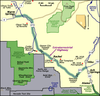
place. I turned west onto Highway 375, "The Extraterrestrial
Highway," which would take me past the famous Area
51. I didn't get far. The whole road was shut down a mile from the
junction. The highway was being worked on by the Nevada Dept. of Transportationnew
asphalt was being put ![]() down.
All the cars on the road had stopped. I got out and talked to a road worker
named Glen, who said there would be a "pilot car" coming to take us through.
A guy on a motorcycle, however, decided to find another route. (The idea
of eating gravel for 10 miles must not have appealed to him.) Glen was
curious about where I came from, where I was going, and where I'd been.
He wanted to travel. He said one of these days he was going to travel,
maybe as far as Maine. "Gonna catch me some lobsters," he said. "Eat me
some lobsters." Just then the pilot car (a truck, actually) came and guided
our little group through the construction zone.
down.
All the cars on the road had stopped. I got out and talked to a road worker
named Glen, who said there would be a "pilot car" coming to take us through.
A guy on a motorcycle, however, decided to find another route. (The idea
of eating gravel for 10 miles must not have appealed to him.) Glen was
curious about where I came from, where I was going, and where I'd been.
He wanted to travel. He said one of these days he was going to travel,
maybe as far as Maine. "Gonna catch me some lobsters," he said. "Eat me
some lobsters." Just then the pilot car (a truck, actually) came and guided
our little group through the construction zone.
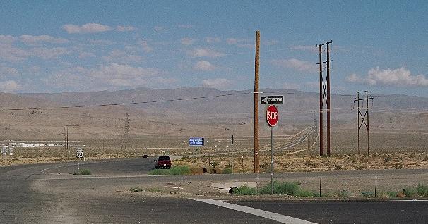
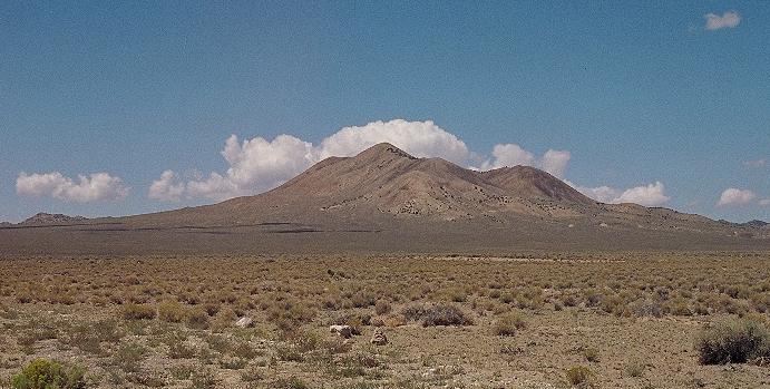
The road winds uphill from there, topping out at the Hancock Summit. Once you're over the top, you get a view of the whole valley. You can see a dirt road scarring the landscape of the valley below. You can see it for miles. It's the road to Groom Lake... Area 51. There's no sign as the dirt road angles off from the highway (between the 34 & 35 mile markers). I stopped to take a picture, and wondered how far you could get down that road before the helicopters start showing up. While the cause of much speculation, Area 51's secrets may not be all that fantastic. The actual Groom Dry Lake borders the Nevada Test Site, where hundreds of nuclear bombs were exploded in the 1950's and 60's. It's a toxic, radioactive wasteland the size of Rhode Island, and not a place you'd want to visit, anyway.
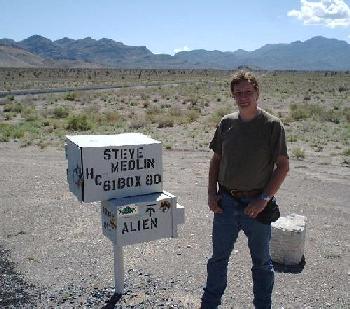
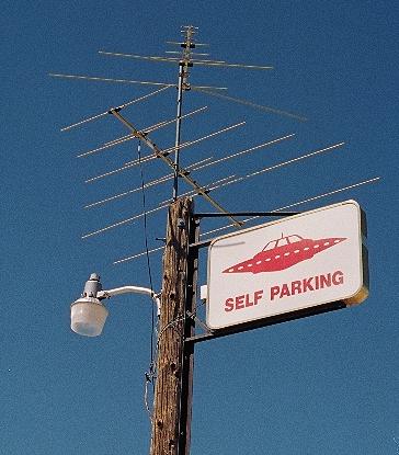
Not far down the road is the famous "Black Mailbox," the site where many UFO-ogists have camped out over the years, watching for alien craft coming out from behind the mountains at night. (These days, the Black Mailbox is cleverly disguised as a white mailbox.) A guy from England was stopped at the mailbox, and we took each other's picture next to it. He said he felt "quite embarrassed" about stopping to look at a mailbox... until I stopped, too. I never got his name. The road goes for about 11 miles in a straight line across the valley floor before topping a low hill. Several miles beyond, I got to the little town of Rachel, Nevada. It's a blink-and-you'll-miss-it little hamlet of shacks and mobile homes, and would probably be easily passed up if not for the mystique of Area 51. I stopped at the Little A'Le'Inn for some pictures and a Dr. Pepper. (I also got a can kozee it was an impulse buy.) It was a homey little small-town bar & grill, a place I wouldn't have minded hanging out at if I'd had the time.
Heading northwest out of Rachel, the mile markers count down to the county line, then start up again. I saw some beautiful mountain scenery, including an unusual black-topped mesa. The area isn't fenced, so you have to watch out for free-range cows. Actually, there are fences, but they separate areas the size of counties, and every now and then you go over a cattleguard in the highway. I crossed the Queen city Summit, the Warm Springs Summit, and the McKinney Tanks Summit, and with each passing dramatic valleys would spread out before me. The pattern of climb climb top wow repeated itself all day. From Rachel, it's 60 miles to Warm Springs, which is more like a bend in the road than a town. All I saw was a cafe. And a dog. He looked like a nice dog. From there, I took Highway 6, "The Midland Trail" through Tonopah until it connected with US Highway 95. The Toiyabe National Forest was unusual in that it didn't seem to have any trees. Okay, a couple, but you'd think they'd have more than a few to call it a "forest." When I passed the Tonopah Test Range later on that afternoon, a sign told me I was on "The Grand Army of the Republic Highway." (Chancellor Palpatine was nowhere in sight.)
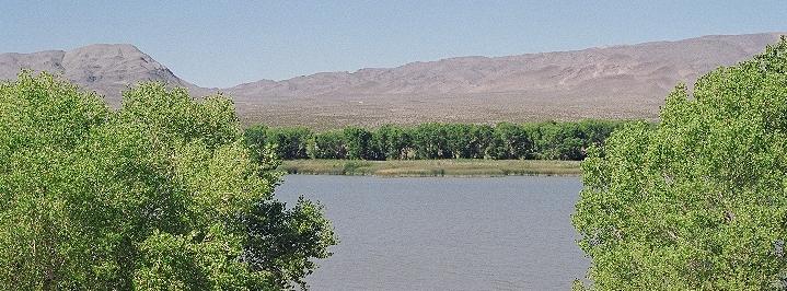
At the old mining town of Tonopah, I stopped for another $20 of gas. I was still hours away from my destination. It was a pretty day for a drive, with lots of happy, perky clouds in the sky. At Mina, Nevada, I passed a store that had a sign out front: "Welcome Burning Man Visitors." Just ouside of Mina was a blue building called the Wild Kat Ranch, featuring "free coffee & showers"... a bordello? (Their website says, "Serving America, one guy at a time!") I went through Luning, and then passed miles of concrete ammunition bunkers at Hawthorne, site of an army ordinance facility. Hawthorne is on the banks of Walker Lake, which had stunningly deep blue water. It took a half-hour to drive around it. The afternoon sun was becoming searing as I turned onto Highway 95A at Schurtz. Trees and green fields greeted me in Yerlington. I made it to Fernley, Nevada by 7 PM (Oklahoma time). I figured it would probably be a good idea to get an extra $10 of gas, just in case. I called Mom and my wife, since I expected my cellphone to quit working soon, and if I died in the desert I wanted them to know I loved them.
Highway 95A turns west on Main Street through the town of Fernley, and heads north under Interstate 80 turning into Highway 427, which almost immediately becomes Highway 447, the Arthur S. Jackson Highway. Fernley marks the beginning of the 40-mile Desert, the most dreaded section of the California Emigrant Trail. It's a hot, unforgiving wasteland that took the lives of many a pioneer...and I was headed into the middle of it. It was another 77 lonely miles to Gerlach. At Nixon, I passed signs welcoming people to Burning Man. One roadside vendor was selling "burning barrels." Past Nixon, the road curves around a mountain overlooking Pyramid Lake, with it's distinctive pyramid-shaped island. I didn't have time to look, though. Traffic on the lonely 2-lane road was thickening, and as the sun set lower in the sky a kind of frantic desperation took over. In moments, I was in the midst of dozens of cars, vehicles of all shapes and sizes, zooming down the narrow highway. It was like a race. It was a race. We were racing the sun, flying down the road as fast as the speed limits would let us, hoping to reach our destination before darkness fell. My heart was racing, too.
A sign in tiny Empire, Nevada declared "Welcome to Nowhere."
Some of the cars stopped at the little store there, but the rest of us
raced on. Gerlach was another small town, with lots of roadside vendors
offering a last chance for supplies. This is the last contact with civilization, ![]() such
as it is, before Burning Man. Traffic kept going, but slowed as the road
got congested. We turned off Highway 447 onto Highway 34, which takes you
to the Black
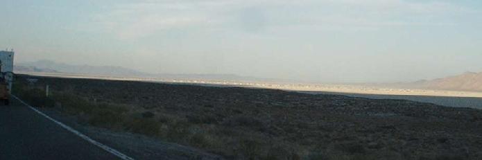
Rock Desert, called by some the flattest place on Earth. The road winds
another 11 miles along the edge of the immense dry lake bed. At last, I
caught a glimpse of something on the horizon-- it was Black Rock City,
Burning Man's temporary community. It spread out across the desert for
milesthousands and thousands of tents, cars, campers, RV's and other vehicles.
such
as it is, before Burning Man. Traffic kept going, but slowed as the road
got congested. We turned off Highway 447 onto Highway 34, which takes you
to the Black
Rock Desert, called by some the flattest place on Earth. The road winds
another 11 miles along the edge of the immense dry lake bed. At last, I
caught a glimpse of something on the horizon-- it was Black Rock City,
Burning Man's temporary community. It spread out across the desert for
milesthousands and thousands of tents, cars, campers, RV's and other vehicles.
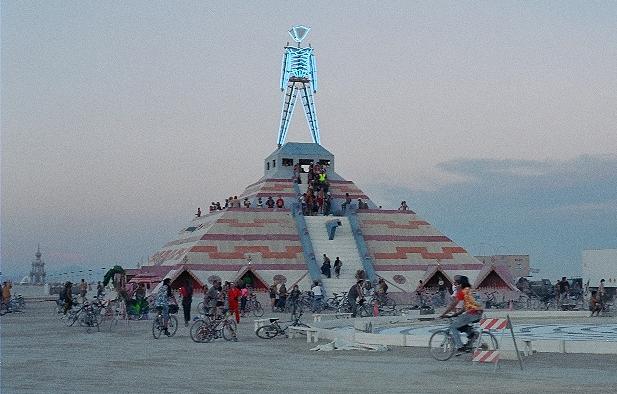
At the gate, a guy stopped me, and my van got a good look-over. Satisfied, the guy tore my ticket and gave me the traditional Burning Man greeting: "Welcome home!" Ahead, one of the Greeters pointed me to the Gate Camp, which was way up close to Center Camp. He encouraged me to adopt a "playa name" while I was at Burning Man, so I chose Tap. That's how I introduced myself to people all week. I drove down Certain Street to the corner of Authority and parked by the side of the road. I'd made it! I was at Burning Man! I should've eaten some supper, but I was too excited. I walked down to the Esplanade and got my first sight of the Man. It was way out in the playa, surrounded by the gigantic campsite. It was a brisk walk out to the Man, a half-mile, and I realized why everyone said to bring a bicycle. Outlined in blue neon, the Man was quite a sight. He stood on top of a huge pyramid, with steps going up almost to the top. I checked out Center Camp, a huge, round tent with couches and benches for talking and stages for performing. There were people doing yoga out in the middle. I walked around the miles of campsites for hours and, well, got a little lost. I was really tired when I finally found my car again. There was already playa dust all over the dashboard. In the eastern sky, Mars was the brightest light in the moonless sky. It was the closest it had been for 60,000 years. The whole sky was amazing. The air was crystal clear, and I could see the Milky Way and all the constellations. I was beat; I'd driven 561 miles that day. I locked up my bicycle to the outside of the car, inflated my air mattress, rolled out my sleeping bag and went to sleep...