 Day 1, August 26: I woke
at 5:30 AM. I had wanted to leave at 6 AM, but first I had to take my youngest
to school. We left right at 7 AM, and after saying goodbye I hit the road.
The sun was just coming up in a cloudless sky as I hit the Broken Arrow
Expressway. Traffic was light. It took barely a half hour to go through
downtown Tulsa. The Sand Springs exit was tricky, since you had to merge
from the outside to the inside lane within a half mile to make it. Graffitti
on one of the overpasses read, "Who would Jesus bomb for oil? Iraq."
I stopped at the Sav-A-Trip in Sand Springs for a Dr. Pepper. Going through
town, I passed a lovely bridge in one of the city parks. As I crossed the
Osage County line, I got a bon voyage text message from my friend Jon.
That was nice of him.
Day 1, August 26: I woke
at 5:30 AM. I had wanted to leave at 6 AM, but first I had to take my youngest
to school. We left right at 7 AM, and after saying goodbye I hit the road.
The sun was just coming up in a cloudless sky as I hit the Broken Arrow
Expressway. Traffic was light. It took barely a half hour to go through
downtown Tulsa. The Sand Springs exit was tricky, since you had to merge
from the outside to the inside lane within a half mile to make it. Graffitti
on one of the overpasses read, "Who would Jesus bomb for oil? Iraq."
I stopped at the Sav-A-Trip in Sand Springs for a Dr. Pepper. Going through
town, I passed a lovely bridge in one of the city parks. As I crossed the
Osage County line, I got a bon voyage text message from my friend Jon.
That was nice of him.
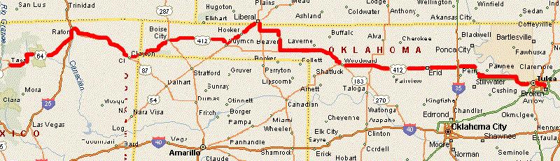
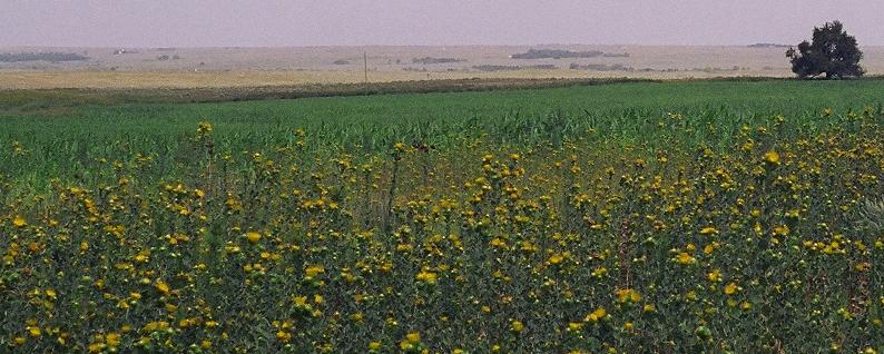
There was hardly any wind at all that morning. I was on Highway 412, headed west. Just over an hour after hitting the road, I got on the Cimarron Turnpike. About ten minutes later, I slowed down for the toll booth. The toll was 75 cents, but when I pulled up, the lady asked me, "You just got on, didn't you?" When I said yeah, she gave me 50 cents change for my dollar. Clouds appeared in the northwest. A car with a licence plate from the Virgin Islands passed me; I thought, boy, is he lost. The sad thing about the Cimarron Turnpike is that you pay the toll twice. I passed the second toll booth just before 9 AM. That was where the great plains really open up. Miles of wide, open prairie, acres of crops to the horizon opened up for me. The only trees stood at attention along fencerows, or clustered together around creekbeds. I crossed the bridge over Interstate 35, where 412 became the Norman A. Lamb Highway. I'd been on this road before, the last time I traveled to Burning Man in 2004. Big, round bales of hay lounged in green fields. The Tulsa radio stations I'd been listening to finally faded away, but I found a lively oldies station. I could've done without the French bashing by the DJ's, though. As I was rolling into Enid, rows of grain elevators paraded past the highway. There was a church sign that read "Enid is Disciple Country." Regular unleaded was selling for $2.46 a gallon in Enid. A traveling carnival was set up in a local mall. I passed the cool old railroad station, and a Mexican restaurant called Playa Azul. It was 91 degrees outside.
Backtracking to Highway 412, I headed west again and crossed
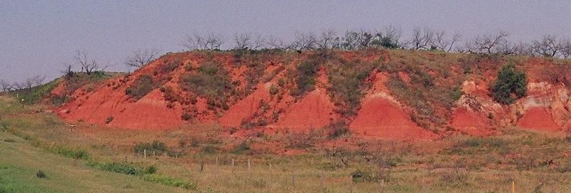
the Cimarron River again. I passed a lonely cemetery outside Curtis; red
rocks mixed with sandy earth. The road took me through Mooreland, Oklahoma,
home of Elizabeth Kinney, Miss Oklahoma for 2004. A gas station was selling
"no lead" gasoline at $2.43 a gallon. Down the road, Woodward was a busy,
bustling town, with lots of passing trucks. That was where Highway 412
turned to the northwest, and is called the 45th Infantry Division Memorial
Highway. The horizon stretched out all around me. I never get tired of
wide-open spaces. Just before noon, I made it to Fort Supply, where the
city hall had a metal roof. Passing signs said I was traveling on George
Nigh's Northwest Passage. Towns are few and far between in the Oklahoma
Panhandle, punctuated with tall grain elevators and lush green fields.
At Otter Creek, I saw a truck in the distance kicking up dust on a dirt
road. I crossed the 37th Parallel, into the area known for years on maps
as No Man's Land. Scattered herds of cattle grazed in broad grasslands.
An American flag flew proudly at the gate to a huge ranch. Just outside
the little community of Slapout, I stopped at a roadside park for lunch:
a ham and cheese sandwich, and two hard-boiled eggs. A tired, worn billboard
tried to give the story of No Man's Land. I sat there for about 15 minutes,
and never saw another car on the road. The prairie really opened up past
there, with visibility 10 miles or more in all directions. With nothing
around for miles, there was nothing to slow down the wind; signs warned
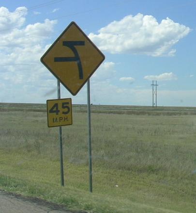
of powerful crosswinds.
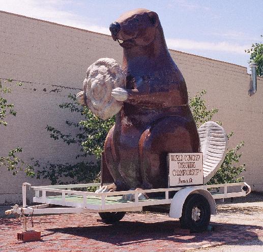
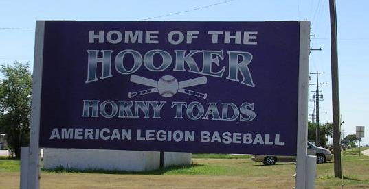
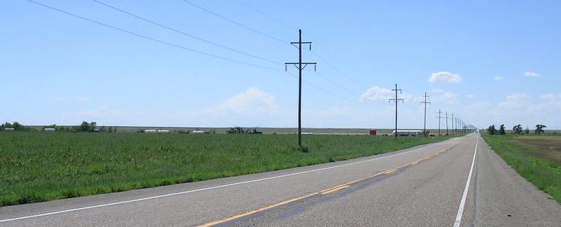
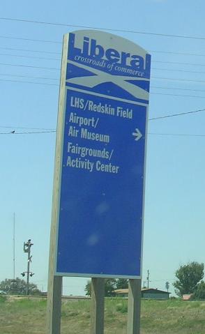
Soon, I traveled through the town of Hooker, Oklahoma. I could see the town's grain elevators from 10 miles away. I thought about stopping to try to find Debbie Krug, whom I went to college with, but even if her family still lived there, I was sure she wouldn't remember me. I did stop to get some pictures. Outside of town, I crossed over the Beaver River. North of Guymon, the land rolled up into short bluffs, like shallow waves on a vast, grassy beach. My original plan was to roll through Guymon and skip through the northern border of Texas, but it was getting late, so I decided to just keep heading west. From Guymon, it was another 62 miles to Boise (the way they pronounce it, it rhymes with "choice") City. I was driving through an ocean of grass. Without the man-made objects around me, there were no landmarks in sight anywhere. I imagined early explorers trudging through that part of the high plains, wondering if they were making any progress at all. Right at 4 PM, I rolled into Boise City. There was a traffic circle around the courthouse. Across the street, art deco touches highlighted the buildings. There was a flagpole monument on the courthouse lawn from 1942, except the flagpole was gone; there was only a round hole in the concrete. Boise City was the only American town bombed during World War II (even if it was us that did the bombing). Nearby, the Santa Fe Trail carried early explorers westward. I headed southwestward on Highway 412, across the Beaver River again; it was little more than a dry gulch at that point. Less than a half hour down the road, a mountain appeared on the horizon ahead.
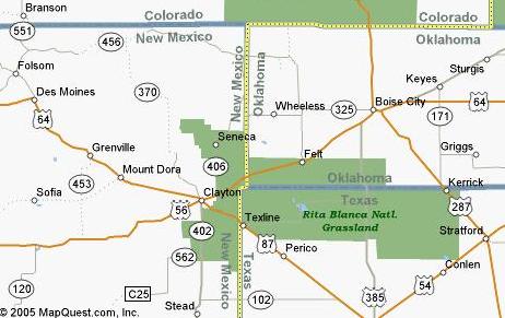 A
few miles ahead was the New Mexico state line but I didn't keep following
the road. Instead, I turned due south down a section line dirt road. I
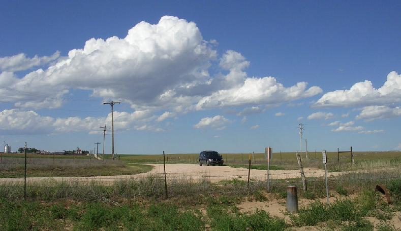
followed the dirt road until it came to a "T," where I parked Satori. This
was the Texas-Oklahoma-New Mexico corner, the point where all three states
met. Just off the road, I found the USGS marker which pinpointed the exact
spot. The road I'd just driven down marked the border between New Mexico
and Oklahoma. The dirt road running east and west marked the northern border
of Texas. It was interesting that the eastern border of New Mexico is not
flush with the Texas border, but extends past it for about a mile, creating
a stumpy "panhandle" for New Mexico. I followed the dirt road west until
it met back up with the highway. It was about another 12 miles to Clayton,
New Mexico, at the foot of the mountain I'd seen on the horizon. It turned
out to be Saddle Mountain. Clayton was a charming little town with narrow,
busy streets. It was blistering hot. The sun had already started its long,
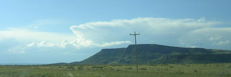
slow crawl into the west. West of Clayton, dark, lurking shapes appeared
on the western horizon. Dark clouds were ahead, too. Even so, an overwhelming,
peaceful calm settled inside me as the grassy miles rolled by. Basketball-sized
chunks of volcanic rock appeared scattered through fields alongside the
road. I was in the Mountain Time Zone, so it was 4:22 local time when I
passed Mt. Dora. It looked like rain ahead. Soon, I picked up some sprinkles.
Lightning flashed in the clouds. Within a few more miles, thunder boomed
ahead as I drove into a curtain of rain. It came down in sheets for a couple
of minutes, the slacked off suddenly. The skies darkened, and regal mountains
rose ahead of me. Satori's gas light came on. Fortunately, there was a
town ahead. I stopped in Des Moines, New Mexico and got $20 of gas at the
little store there. The rain had cooled the air down, but not much. To
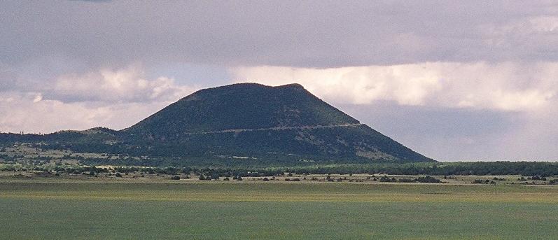
the west, the impressive Capulin Volcano dominated the landscape. I'd read
that Capulin was a young volcano, perhaps only 10,000 years old. Houses
and mobile homes were settled in all around the peak, a little too close
for me. There was lots of prehistoric volcanic debris everywhere. It was
the closest I'd been to a violent volcano, not counting a close friend's
temper (and you didn't hear that from me).
A
few miles ahead was the New Mexico state line but I didn't keep following
the road. Instead, I turned due south down a section line dirt road. I
followed the dirt road until it came to a "T," where I parked Satori. This
was the Texas-Oklahoma-New Mexico corner, the point where all three states
met. Just off the road, I found the USGS marker which pinpointed the exact
spot. The road I'd just driven down marked the border between New Mexico
and Oklahoma. The dirt road running east and west marked the northern border
of Texas. It was interesting that the eastern border of New Mexico is not
flush with the Texas border, but extends past it for about a mile, creating
a stumpy "panhandle" for New Mexico. I followed the dirt road west until
it met back up with the highway. It was about another 12 miles to Clayton,
New Mexico, at the foot of the mountain I'd seen on the horizon. It turned
out to be Saddle Mountain. Clayton was a charming little town with narrow,
busy streets. It was blistering hot. The sun had already started its long,
slow crawl into the west. West of Clayton, dark, lurking shapes appeared
on the western horizon. Dark clouds were ahead, too. Even so, an overwhelming,
peaceful calm settled inside me as the grassy miles rolled by. Basketball-sized
chunks of volcanic rock appeared scattered through fields alongside the
road. I was in the Mountain Time Zone, so it was 4:22 local time when I
passed Mt. Dora. It looked like rain ahead. Soon, I picked up some sprinkles.
Lightning flashed in the clouds. Within a few more miles, thunder boomed
ahead as I drove into a curtain of rain. It came down in sheets for a couple
of minutes, the slacked off suddenly. The skies darkened, and regal mountains
rose ahead of me. Satori's gas light came on. Fortunately, there was a
town ahead. I stopped in Des Moines, New Mexico and got $20 of gas at the
little store there. The rain had cooled the air down, but not much. To
the west, the impressive Capulin Volcano dominated the landscape. I'd read
that Capulin was a young volcano, perhaps only 10,000 years old. Houses
and mobile homes were settled in all around the peak, a little too close
for me. There was lots of prehistoric volcanic debris everywhere. It was
the closest I'd been to a violent volcano, not counting a close friend's
temper (and you didn't hear that from me).
I headed on down the road towards Raton. Above, thunderheads were forming, their anvil tops flattening out in the last heat of the day. The road ascended into the opening stanzas of the Rocky Mountains. My ears popped. The overture was yet to come. At Raton, I turned south on Interstate 25 for a few miles, until Highway 64 turns west. I was in a wide mountain valley, and I'd picked up a pretty fierce headwind. The sun was awfully close to the horizon, the western sky darkened by clouds. I was still 90 miles from Taos. Just the, Chester sent a text message. At a ranch, a donkey wallowed in a cloud of dust. I crossed over Crow Creek and entered a long, wide valley headed towards Cimarron. The wind shifted, which only meant I was battling cross winds instead of headwinds. Two and a half hours past Des Moines, I passed through Cimarron, "Where the Rockies Meet the Plains." In the sky, a big hole opened up in the clouds, and a beam of sunlight punched through to the mountains below, as if to show me the way. Twisty, turning roads descended into Cimarron Canyon. Twenty minutes later, I was still going downhill, deeper and deeper into the canyon. The wind turned icy. It was still light out, even through the sun had disappeared behind the mountains. On the side of the road, I passed a 6-point deer, casually grazing. The car ahead of me had to swerve to avoid a 4-point deer that had wandered into the road. Incredible cliffs towered above me. After a half hour, the road finally started to climb out of the canyon. Cresting at just over 8,000 feet elevation, the road circled around Eagles Nest Lake, a Shangra-La-esque retreat high in the New Mexico mountains. The road wound down and around the lake, that was simply beautiful. A chilly, stout wind surrounded me. The road evened out, and the sun came out blazing.
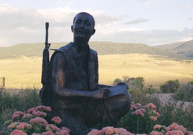
This was where I took a short side trip. Down from Eagles Nest is a narrow road winding up the side of a hill. The setting sun blinded me as I tried to aim Satori up the road. At the top, the wind was brisk but completely silent. This was the National Vietnam Veterans Memorial. The memorial itself had closed for the day, but the grounds were open. The view of the surrounding mountains is thrilling. There was a full-scale Huey helocopter on display, tilted to one side as if in distress, as well as statues and various little memorials. The only sound was a gentle rustle of wind through the trees. The place has a sad, and yet hopeful feel to it. You could tell a lot of love went into putting the place together.
It was getting dark when I finally arrived in Taos, just before 8 PM local time. I drove into town and pulled into the McDonald's parking lot to check my directions again. It turned out the hostel I was staying at wasn't exactly in Taos, but rather in a little town called Arroyo Seco, 9 miles north of Taos. I stopped for some directions, then pulled up Paseo Del Pueblo and headed north. Five miles past the turnoff, I was questioning if I'd taken the right road, when the hostel suddenly appeared ahead. It was called the Abominable Snowmansion, and seemed to be the biggest business in the sleepy little town. I got checked in at the front desk, where they gave me sheets, blankets, a towel and a pillowcase. I was sleeping in the dormitory, and at the time the only other guy in there was a German tourist named Deitrich. I got settled in, then checked out the kitchen. It was a big, diner-sized kitchen, with plenty of pots, pans and utensils. I cooked myself a bowl of soup for my supper. As I ate, I chatted with a girl named Margaret, a pretty, blonde computer tech from Atlanta. She was traveling with her boyfriend, and kidded him about flirting with two German girls. I wanted to read a little, but I was really bushed after 14 hours on the road. I'd driven 696 miles that first day. Outside, the Milky Way stretched out across the sky dazzling. The hostel had a pool table and plenty of space to relax. Private rooms were upstairs, and outside there were even teepees you could sleep in. By the time I finished my soup, there were about five guys in the dormitory. I made my bed, and settled down in my bunk for the night. I didn't have any trouble falling asleep.

 |
 |
|
|
|


|
|
| Links:
Little Sahara State Park National Vietnam Veterans Memorial Abominable Snowmansion Taos, New Mexico |
Last updated: February, 2006
All original content (c)opyright 2005 by Tim Frayser Comments: tapestry01@yahoo.com |