
 Day 2, August 27: The guy in
the next bunk down from me in the dorm faced the opposite way, so he slept
with his head was only a foot or so from mine. Some time in the night,
he talked in his sleep: "Um..." That's all he said, but I was awake
in an instant, every prison movie I'd ever seen flashing through my head.
When I didn't get "shivved" right away, I relaxed and fell back asleep.
I woke up at daybreak Saturday morning, after getting almost 10 hours of
sleep. I felt great. After a shower, I started packing up. A fluffy white
cat in the parking lot checked me out. In the hallway, I asked a German
tourist if he slept well, and he said, "Ja, is good sleep." Hostels must
be much more common in Europe, I figured. The Snowmansion was very comfortable,
and I would absolutely recommend it to anyone traveling in the area. Breakfast
was nuts, dried fruit and V-8 Juice. I turned in my bedding and hit the
road again.
Day 2, August 27: The guy in
the next bunk down from me in the dorm faced the opposite way, so he slept
with his head was only a foot or so from mine. Some time in the night,
he talked in his sleep: "Um..." That's all he said, but I was awake
in an instant, every prison movie I'd ever seen flashing through my head.
When I didn't get "shivved" right away, I relaxed and fell back asleep.
I woke up at daybreak Saturday morning, after getting almost 10 hours of
sleep. I felt great. After a shower, I started packing up. A fluffy white
cat in the parking lot checked me out. In the hallway, I asked a German
tourist if he slept well, and he said, "Ja, is good sleep." Hostels must
be much more common in Europe, I figured. The Snowmansion was very comfortable,
and I would absolutely recommend it to anyone traveling in the area. Breakfast
was nuts, dried fruit and V-8 Juice. I turned in my bedding and hit the
road again.
Inside, it was very peaceful. People were just stirring on a sleepy Saturday morning. I walked quietly, respectful not only of the folks living in the pueblo but of the spirits of generations before them. All the buildings of the pueblo put together only take up about the space of a city block. There's no electricity in the pueblo, to preserve its historic state, but I did see some modern conveniences, such as propane tanks and pipes from wood-burning stoves. In a window, I spotted a transistor radio. Still, the pueblo remains much like it did a thousand years ago. A small creek gurgles its way through the middle of the pueblo, and sitting on the narrow bank it was easy to imagine people waking up on a sleepy summer morning centuries past. I stepped inside the ancient St. Jerome's Church, also called San Geronimo, and said a little prayer. I walked past the graveyard. Rough wooden crosses and stone markers poke out of the tall grass. I had expected the cemetery to be full of ancient graves, but the oldest I saw was from the 1970's. There was a grave of somebody that died as recently as 2002. Because of the weather, the adobe walls of the pueblo have to be renewed every year with a fresh layer. It was a reminder that "culture," like many other things, isn't something that's static, set down in books and pub on display in museums. It's alive, constantly growing, evolving and replenishing itself. That which does not grow, dies and it was heartening to see the Taos Pueblo continue to nourish life. I got some gasoline, and headed west from Taos. A low-flying plane pointed to the municipal airport just outside town.
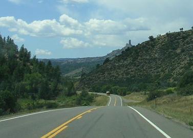
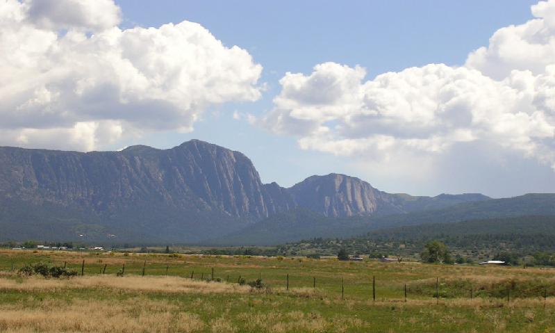
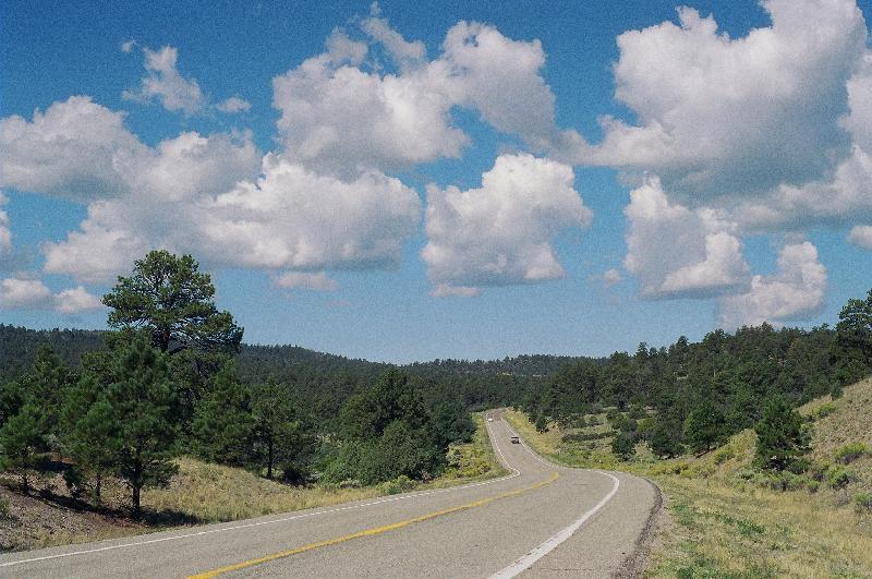
Outside of Tierra Amarilla, I passed a farmhouse flying a tattered Israeli flag. When I got to Chama, I thought I had missed a turnoff and started to turn around, but then I saw a sign for Dulce, New Mexico, 25 miles away by Highway 84 north. So, I turned north. The road took me more west than north, over some recently-graveled highway. A sign beside the road took me by surprise: I was crossing the Continental Divide. I stopped to take a picture. That was the end of my fourth roll of film for the trip. Down the road, Highways 64 and 84 diverge. I stayed on Highway 84, headed north towards Chromo, Colorado. Just before noon local time I crossed the border into Colorado. Impossibly high purple mountains loomed ahead. The highway got narrow as I entered the San Juan National Forest. There were free range cows about, too. A half hour later I rolled into Pagosa Springs, a lively tourist town in the Rockies. I was needing to stop for gas, so I started hunting around for a place with reasonable prices. Just then, a Giant station came into view advertising unleaded gas for $2.62 a gallon. That was about the best price I'd seen since leaving home, so I pulled in. The station was having a grand opening celebration, and was doing a brisk business. There were balloons, free ice cream, games for the kids it was packed. A contributing factor was the rumor that the station was going to be selling gas for $1.99 a gallon, a rumor the station staff emphatically denied.
 After
getting $20 of gas, I headed down Highway 160 west. I had already seen
one Chimney Rock that year, near Scott's Bluff, Nebraska, but Colorado
had one, too. I spotted it from four miles away, poking up from between
the mountains. I thought there would be some sort of visitor's center,
or historical marker, but there was nothing at the base but a roadside
diner. I pulled into the parking lot and ate my packed lunch for the day.
Clouds closed in as I ate, and I got some sprinkles. At a business next
to the diner advertising "game processing," a guy was doing something outside
with a power saw; I didn't look to see what he was cutting. After eating,
I used the rest room in the diner. When I came back out, something buzzed
in front of my face. It was a hummingbird, happily gliding through the
air like a magical fairy. The skies were still unsettled as I backtracked
to Highway 151 and turned south towards Ignacio. The air smelled clean
and fresh. The road was winding, but not steep. It followed the river past
several gorgeous panoramas. I was on the Ute Reservation, and even through
the skies were stormy the landscape was really pretty. The only other times
I'd been through Ignacio were during the winter, when everything was dark
and dead and Mordor-ish, but the valley eventually widened into a verdant,
cheerful terrain. I drove through the little villages of Allison and Tiffany.
The wind picked up, and it looked like it was raining off to the south.
After
getting $20 of gas, I headed down Highway 160 west. I had already seen
one Chimney Rock that year, near Scott's Bluff, Nebraska, but Colorado
had one, too. I spotted it from four miles away, poking up from between
the mountains. I thought there would be some sort of visitor's center,
or historical marker, but there was nothing at the base but a roadside
diner. I pulled into the parking lot and ate my packed lunch for the day.
Clouds closed in as I ate, and I got some sprinkles. At a business next
to the diner advertising "game processing," a guy was doing something outside
with a power saw; I didn't look to see what he was cutting. After eating,
I used the rest room in the diner. When I came back out, something buzzed
in front of my face. It was a hummingbird, happily gliding through the
air like a magical fairy. The skies were still unsettled as I backtracked
to Highway 151 and turned south towards Ignacio. The air smelled clean
and fresh. The road was winding, but not steep. It followed the river past
several gorgeous panoramas. I was on the Ute Reservation, and even through
the skies were stormy the landscape was really pretty. The only other times
I'd been through Ignacio were during the winter, when everything was dark
and dead and Mordor-ish, but the valley eventually widened into a verdant,
cheerful terrain. I drove through the little villages of Allison and Tiffany.
The wind picked up, and it looked like it was raining off to the south.
I pulled into Ignacio just after 2 PM local time. The blustery wind kicked up clouds of dust through the streets. Several bars had "welcome bikers" signs out front. My sister had lived in Ignacio for a couple of years, so I wanted to visit it again. I took some pictures of the main street and the church, hoping there was something my sister would remember. I wanted to get a picture of the house she lived in , but her address was always a post office box. So, I took a picture of the post office. The town center building had little stone dinosaur out front. On the way out of town, I passed the Sky Ute Casino, the source of much profit and sorrow for the local youth. I turned south towards Farmington. The highway made a harrowing climb up the side of a mountain, then skirted the cliffs for another twelve miles before winding back down to the valley floor. I passed a turnoff for... Ignacio, and wondered if the directions from the Internet might have been more accurate.
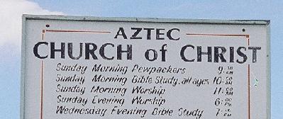
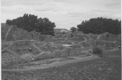
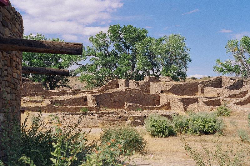
It was raining again when I crossed the border back into New Mexico. The rain stopped as I arrived in the town of Aztec, but it was still wet and windy out. The Main street was called Main Avenue. I passed a motel called the Step Back Inn, and a business called the Pierced Buddha. I had not been to Aztec since I was a little kid, so I had to stop and see the Aztec Ruins. I remembered the ruins being way outside of town, but the town had grown since then. There were houses all around the ruins now. There was even an RV park right across the street from them. Still, the ruins held a special place in my childhood memory. I had a picture I took during my first visit. I took it with my first camera, a simple box camera that came with a Christmas toy. Inside the ruins, I was able to find the exact spot where I took that picture, and it was like stepping back through time. The surrounding town might have changed, but the ruins had their same, timeless charm. I like to think many happy families once lived there. The skies had turned blue again, and it looked like it was going to be a nice day. I left my childhood picture with the gift shop lady, so they could see what the ruins looked like years before.
 From
Aztec, I headed south through Bloomfield, "The Heart of the 4 Corners."
Turning west on Highway 64, there were some dramatic cliffs ahead. At 4:23
local time, I got to Farmington. It's a big town, and it took me a while
to get through. The sun was out, and seemed to be boiling away the clouds.
Traveling westward, a shape appeared ahead. It was Shiprock, impressive
even through I was still 23 miles away. I was entering the land
of titans. The highway skirted beneath some high sandstone cliffs. A girl
at a stop light had an oldies station blaring on her car radio, which I
was able to happily find. There were several cars and pickups parked alongside
the road selling fresh "kneel down bread," which I had never heard of before.
I think it's something like a tamale.
From
Aztec, I headed south through Bloomfield, "The Heart of the 4 Corners."
Turning west on Highway 64, there were some dramatic cliffs ahead. At 4:23
local time, I got to Farmington. It's a big town, and it took me a while
to get through. The sun was out, and seemed to be boiling away the clouds.
Traveling westward, a shape appeared ahead. It was Shiprock, impressive
even through I was still 23 miles away. I was entering the land
of titans. The highway skirted beneath some high sandstone cliffs. A girl
at a stop light had an oldies station blaring on her car radio, which I
was able to happily find. There were several cars and pickups parked alongside
the road selling fresh "kneel down bread," which I had never heard of before.
I think it's something like a tamale.
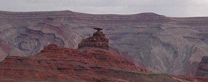
Just after 5 PM local time, I passed through Shiprock, and apparently drove through one of the most dangerous intersections in the country. West of town, I was back in familiar territory again. Down the road, I passed the spot where I saw the accident the year before. Everything had been fixed, and you couldn't tell anything had happened there at all. Ahead, the road seemed to dropped off the Earth, just like I remembered it. Over the border into Arizona, I passed the little store at Teec Nos Pas, which wasn't so little any more. There was some heavy equipment parked out front. It looked like they were putting in some gasoline tanks. I continued westward, into new territory for me. The skies started to darken again. Satori was hit with some surprisingly strong winds. Dark shapes appeared far off on the horizon.
 Right
at 6 PM local time, I turned north on Highway 191. It was a modern, well-maintained
two-lane road, until I crossed the border into Utah. Thousands of years
of history revealed themselves in the rock strata alongside the road. Above,
the skies became more unsettled. I saw lightning. The clouds churned and
boiled, and seemed to act out hidden aggressions. Clearly, they had issues.
Passing the remote Todo Baptist Church, I picked up some sprinkles. The
road surface became rougher as it turned west towards Mexican Hat. There
were dramatic cuts in the Earth, which had turned red. Ghostly monoliths
rose out of the gathering dusk. At Mile Marker 29, I passed the turn for
the Valley of the Gods. Down the road was the turn for Gooseneck State
Park. I had intended to stop there, but it was so late in the day I knew
I wouldn't get any good pictures. I earmarked it for some future trip.
I had already passed a couple of Gooseneck-y valleys, anyway. The wind
was picking up, and I needed to find my campground soon. The road turned
south. I passed the rock called Mexican Hat. The town of Mexican Hat was
just a little further, and several travelers had already hunkered down
there against the inclement weather. It was another 30 miles to my campground.
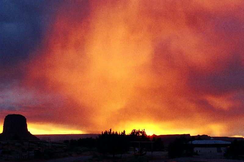
I was in Monument Valley, but couldn't see anything. The wind was kicking
up clouds of red dust. The van was battered, and swerved all over the road.
Plants were flattened against the ground by the stiff breeze. This was
grab the kids & head for the basement kind of weather... but
there was no basement in the valley, no tornado sirens, nothing to warn
of impending doom until it impended right on top of you. Off to the side
of the road, I saw some cars, but no signs. To the east, I thought I saw
some picnic tables, but no way to get to them. Blowing red dust made the
road disappear. Finally, the sign appeared for the campground, which was
still a half mile off the road. I pulled into a campsite. The wind stung
my eyes as I went inside to pay for the night. I pointed outside and asked
the attendant, "Is it like this a lot?" He just shrugged and nodded. Minutes
later, however, the wind finally died down. Campers emerged from their
cars and tents like they'd just survived a natural disaster. To the west,
the sun broke through the clouds, and the most amazing thing happened.
The air was choked full of dust, and the last rays of the day created a
brilliantly red sunset. It looked like the whole sky was on fire. Absolutely
beautiful.
Right
at 6 PM local time, I turned north on Highway 191. It was a modern, well-maintained
two-lane road, until I crossed the border into Utah. Thousands of years
of history revealed themselves in the rock strata alongside the road. Above,
the skies became more unsettled. I saw lightning. The clouds churned and
boiled, and seemed to act out hidden aggressions. Clearly, they had issues.
Passing the remote Todo Baptist Church, I picked up some sprinkles. The
road surface became rougher as it turned west towards Mexican Hat. There
were dramatic cuts in the Earth, which had turned red. Ghostly monoliths
rose out of the gathering dusk. At Mile Marker 29, I passed the turn for
the Valley of the Gods. Down the road was the turn for Gooseneck State
Park. I had intended to stop there, but it was so late in the day I knew
I wouldn't get any good pictures. I earmarked it for some future trip.
I had already passed a couple of Gooseneck-y valleys, anyway. The wind
was picking up, and I needed to find my campground soon. The road turned
south. I passed the rock called Mexican Hat. The town of Mexican Hat was
just a little further, and several travelers had already hunkered down
there against the inclement weather. It was another 30 miles to my campground.
I was in Monument Valley, but couldn't see anything. The wind was kicking
up clouds of red dust. The van was battered, and swerved all over the road.
Plants were flattened against the ground by the stiff breeze. This was
grab the kids & head for the basement kind of weather... but
there was no basement in the valley, no tornado sirens, nothing to warn
of impending doom until it impended right on top of you. Off to the side
of the road, I saw some cars, but no signs. To the east, I thought I saw
some picnic tables, but no way to get to them. Blowing red dust made the
road disappear. Finally, the sign appeared for the campground, which was
still a half mile off the road. I pulled into a campsite. The wind stung
my eyes as I went inside to pay for the night. I pointed outside and asked
the attendant, "Is it like this a lot?" He just shrugged and nodded. Minutes
later, however, the wind finally died down. Campers emerged from their
cars and tents like they'd just survived a natural disaster. To the west,
the sun broke through the clouds, and the most amazing thing happened.
The air was choked full of dust, and the last rays of the day created a
brilliantly red sunset. It looked like the whole sky was on fire. Absolutely
beautiful.
Night descended quickly in the valley. The campsite had large, clean restrooms. I'd read online that it had coin-operated showers, but it didn't say they took tokens, not change. There weren't any instructions on how to get tokens. Still, it was nice to just not be moving. Sitting on a picnic table, German tourists nearby, I finished off the last of the hard-boiled eggs I'd packed. Above, the sky was completely overcast. No star watching for me, I figured. I got out my flashlight and read for a while, then spread out on the foam mattress in the back of the van and quickly fell asleep. Some time late that night, I woke, looked up, and through the windows saw stars. Outside, the sky had cleared, and the stars were a limitless carpet of diamonds. A crescent Moon hung low on the horizon. It was thrilling and peaceful at the same time. I said goodnight to the stars, climbed back inside, and went back to sleep.

 |
 |
|
|
|
|
|
| Links:
Taos Pueblo Carson National Forest Chimney Rock Aztec Ruins Monument Valley |
All original content (c)opyright 2005 by Tim Frayser
Comments: tapestry01@yahoo.com Last updated: September, 2005 |