 The boom of thunder woke me just after 2 AM. Lightning flashed, followed
by the patter of rain. Through the trees, I could see the dome tent of
my neighbors lit up from within like a nightlight. The rumble of thunder
rocked the van. The storm took a half hour break, and then came back for
another round. Everything settled down about 3:20, and I was abut to go
back to sleep when PLORK, a drop of water fell on my head. Whered that
come from? A light shone through one of the windows; the Moon had broken
out from behind the clouds. I watched someone with a flashlight cross through
the campground and go into the lit-up dome tent. At some point, I fell
back asleep
The boom of thunder woke me just after 2 AM. Lightning flashed, followed
by the patter of rain. Through the trees, I could see the dome tent of
my neighbors lit up from within like a nightlight. The rumble of thunder
rocked the van. The storm took a half hour break, and then came back for
another round. Everything settled down about 3:20, and I was abut to go
back to sleep when PLORK, a drop of water fell on my head. Whered that
come from? A light shone through one of the windows; the Moon had broken
out from behind the clouds. I watched someone with a flashlight cross through
the campground and go into the lit-up dome tent. At some point, I fell
back asleep
I woke just before sunrise. Id given up trying to tell time on the
Rez. It was Friday, August 23rd. Even with the storm, I figured
I got about 7 hours of sleep. Outside, everything was wet, including the
camp chair I forgot to pack up. Water spilled out when I tipped it over.
At the restroom, I poured water over my head to wash my hair. An older
gentleman came in to shave. He said there were wild dogs wandering the
campground, looking for handouts. That was why the trashcans were all set
up in racks, 2 feet off the ground. I got out the stove and cooked up some
ramen noodles for breakfast. When I packed up the van, I put the wet chair
up on top of the water jugs to dry out. I had a long way to go that day.
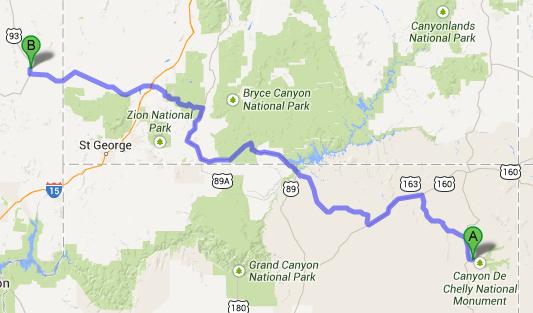
 I headed out just before 8:30. I stopped at the Shell station for gas,
because, of course, it was cheaper than the Chevron station. The convenience
store had a Laundromat. Most of the washers were full. It was a cool, brisk
morning. Lots of people were out along the highways walking to work. Dogs
played in a fenced yard. It was a brisk morning. My original plan was to
take Highway 191 north from Chinle to Highway 160 and head west, but then
I discovered I could save 40 miles by taking Indian Route 59 west to Kayenta.
Highway 191 was good asphalt, with no shoulders. I passed small, family
farms, many with hogons, new and ancient. Red cliffs followed the road
as I went north. I found a Fleetwood Mac song on the radio.
I headed out just before 8:30. I stopped at the Shell station for gas,
because, of course, it was cheaper than the Chevron station. The convenience
store had a Laundromat. Most of the washers were full. It was a cool, brisk
morning. Lots of people were out along the highways walking to work. Dogs
played in a fenced yard. It was a brisk morning. My original plan was to
take Highway 191 north from Chinle to Highway 160 and head west, but then
I discovered I could save 40 miles by taking Indian Route 59 west to Kayenta.
Highway 191 was good asphalt, with no shoulders. I passed small, family
farms, many with hogons, new and ancient. Red cliffs followed the road
as I went north. I found a Fleetwood Mac song on the radio.
 It was right after 9 AM when I turned west onto IR 59. It was 51 miles
to Kayenta. The road climbed up onto a lonely mesa. The early morning Sun
cast deep shadows among the red rocks. A white mule grazed beside the road.
The road took me up onto a high plain following a striped ridge. I drove
between two free range cows grazing along the highway. The radio offered
lots of Christian and/or country-western stations. I turned it off. At
Mile Marker 18, the road dropped down off the mesa, then pulled into a
short maze of buttes before coming out onto a grey plain. The road took
a steep climb through some deep cuts in the cliffs into a pretty country
of rich colors. Cloud shadows played across the ridge. At Chilbento, a
car was nose-to-nose with an SUV, as if giving it a jump. The van scared
a pair of black carrion birds off their roadkill breakfast. The road came
to a T at Church Rock, and I turned west on Highway 160. I breezed through
Kayenta just before 10 AM. There was an exhibit on Navajo Code Talkers
at the Burger King. The road took a long, slow uphill grade out of town.
I passed some more free range cows grazing beside the road. Seven miles
out of Kayenta I topped 6,000 feet elevation, then dropped down into a
long, wide valley.
It was right after 9 AM when I turned west onto IR 59. It was 51 miles
to Kayenta. The road climbed up onto a lonely mesa. The early morning Sun
cast deep shadows among the red rocks. A white mule grazed beside the road.
The road took me up onto a high plain following a striped ridge. I drove
between two free range cows grazing along the highway. The radio offered
lots of Christian and/or country-western stations. I turned it off. At
Mile Marker 18, the road dropped down off the mesa, then pulled into a
short maze of buttes before coming out onto a grey plain. The road took
a steep climb through some deep cuts in the cliffs into a pretty country
of rich colors. Cloud shadows played across the ridge. At Chilbento, a
car was nose-to-nose with an SUV, as if giving it a jump. The van scared
a pair of black carrion birds off their roadkill breakfast. The road came
to a T at Church Rock, and I turned west on Highway 160. I breezed through
Kayenta just before 10 AM. There was an exhibit on Navajo Code Talkers
at the Burger King. The road took a long, slow uphill grade out of town.
I passed some more free range cows grazing beside the road. Seven miles
out of Kayenta I topped 6,000 feet elevation, then dropped down into a
long, wide valley.
 Down the road, I stopped at the Black Mesa Shopping Center, near the turnoff
for Navajo National Monument. Ever since that morning, Id been hearing
a ringing sound, but didnt know where it was coming from. I figured something
in the stuff Id packed on the roof was banging together. Satori was a
little low on oil, so I put in a quart and let it cool down a little while
I went inside. The grocery store was clean, well-lit, and had an assortment
of canned goods. A sign at the register told patrons that were rude, intoxicated
or unruly to please bless another place of business with your presence.
A can of Campbells soup cost $2.39. I got a Dr. Pepper.
Down the road, I stopped at the Black Mesa Shopping Center, near the turnoff
for Navajo National Monument. Ever since that morning, Id been hearing
a ringing sound, but didnt know where it was coming from. I figured something
in the stuff Id packed on the roof was banging together. Satori was a
little low on oil, so I put in a quart and let it cool down a little while
I went inside. The grocery store was clean, well-lit, and had an assortment
of canned goods. A sign at the register told patrons that were rude, intoxicated
or unruly to please bless another place of business with your presence.
A can of Campbells soup cost $2.39. I got a Dr. Pepper.
Thirteen miles down the road, I turned north on Highway 98. I was on
the Naattsisaan Navajo Mountain Scenic Road. Id been this way before.
I figured Id be in Page by noon. Up ahead, traffic stopped for construction.
It looked like the project was to turn the road into a 4-lane highway.
I turned off the engine and waited for the pilot car to take traffic through.
I didnt have to wait long. The high desert was full of life; hearty plant
growth was everywhere. It was 11:18 when the road topped 6,687 feet elevation.
My ears popped. The rock outcroppings along the highway were stunning.
A sign beside the road read In Beauty We Walk. I passed the power
plant and the turn for Antelope Canyon, which Id visited years before.
Coming over a rise, I got to see the Vermillion Cliffs, a stunning work
of nature. It was shortly after noon when I drove through Page. I went
past the high school and took a wrong turn somewhere, but still ended up
on the right end of town. I crossed the Glen Canyon Dam and got a glimpse
of Lake Powell. There were not as many RVs for sale beside the road as
there were last time I passed through.
 The wind really picked up on the north end of the river. Clouds were moving
in. It was 12:44 Oklahoma time when I crossed the border into Utah. It
was 64 miles to Kanab, and about four hours to Cathedral Gorge. The landscape
was very rugged. I figured out what the ringing sound was: the little license
plate on my bicycle was coming loose. I pulled over at a historical marker
commemorating the Pahreah ghost town. A movie set was built over the remains
of a ghost town about 4 miles from the highway, and several western movies
had been filmed there over the years. The marker also commemorated the
Old Spanish Trail, which ran nearby. I removed the plate and took a few
minutes to eat a bite of lunch. Ahead, steep grades led me past maroon
cliffs and ruddy red mountains. The sky was overcast, with patches of blue
here and there.
The wind really picked up on the north end of the river. Clouds were moving
in. It was 12:44 Oklahoma time when I crossed the border into Utah. It
was 64 miles to Kanab, and about four hours to Cathedral Gorge. The landscape
was very rugged. I figured out what the ringing sound was: the little license
plate on my bicycle was coming loose. I pulled over at a historical marker
commemorating the Pahreah ghost town. A movie set was built over the remains
of a ghost town about 4 miles from the highway, and several western movies
had been filmed there over the years. The marker also commemorated the
Old Spanish Trail, which ran nearby. I removed the plate and took a few
minutes to eat a bite of lunch. Ahead, steep grades led me past maroon
cliffs and ruddy red mountains. The sky was overcast, with patches of blue
here and there.
Just after 2 PM, I arrived in Kanab, A Western Classic. I stopped
at the BLM Visitor Center and looked through their exhibits on geology
and archaeology. I got a phone call from somebody at human resources: they
wanted me to come in for an interview. Um, I said, I'm in Utah,
in the middle of a journey
could we set it up for after Labor Day? He
said they couldnt wait that long, and suggested a phone interview. I remembered
how impossible it was to get cell service on the playa, and said Id call
him back. I was afraid something like that would come up while I was on
the road. It made me sick to think Burning Man could cost me a possible
job. Kanab had a very busy downtown district. The local RV park was completely
full. I stopped at a gas station and topped off the tank. I had a long
way to go the next day.
I turned north out of town towards ominous clouds. Wooded hills of
the Dixie National Forest rose all around me. I passed the exit for Coral
Pink Sand Dunes State Park, but I knew I wouldnt get any good pictures
with an overcast sky. Right before 3 PM, I turned west onto Highway 14
at Mt. Carmel Junction. Right away, it seemed like Id bitten off more
than I could chew. Signs warned of steep grades ahead. Snow tires were
required from November to March. On top of everything else, it started
to rain. Steep grades slowed me down to 35, then 30 MPH. Locals stuck behind
me were frustrated at not being able to pass. Edges of the narrow, tight
road plunged off into oblivion. I passed campgrounds full of campers. Scary,
twisty roads offered brief glimpses of breathtaking mountain passes, but
I was too busy trying to not die to dare take a peek. I could see black
lava rocks scattered among the trees. It was a strange sight to see Navajo
Lake appear through a break in the forest. The road leveled out. Sheep
grazed in a field. Another sign warned of avalanches. The highway started
back down out of the mountains, through tight turns and more steep grades.
 It was a quarter after 4 when I finally pulled into Cedar City, Utah. I
had to pull over and sit for a few minutes. It was as scary a highway as
Id ever been on. I got out my cellphone and called the human resources
office. I told the guy if we scheduled a phone interview, I would find
some way to be in a place where I could get cell service. We agreed on
Tuesday afternoon at 3 PM Central Time. I was giggling all the way out
of town. You gotta have hope!
It was a quarter after 4 when I finally pulled into Cedar City, Utah. I
had to pull over and sit for a few minutes. It was as scary a highway as
Id ever been on. I got out my cellphone and called the human resources
office. I told the guy if we scheduled a phone interview, I would find
some way to be in a place where I could get cell service. We agreed on
Tuesday afternoon at 3 PM Central Time. I was giggling all the way out
of town. You gotta have hope!
I drove west; it was 41 miles to Enterprise. The highway set out in
a straight, 2-lane asphalt line across a wide plain, but steep grades rose
to meet me. Mountains loomed at all sides. It was right before 5 PM when
I went through Newcastle, surrounded by corn fields and pasture land. Huge
irrigation machines lined the road, some at work watering the crops. Beryl
Junction was where I passed the turnoff for Enterprise. No one else was
on the road in any direction. At 5:32 I crossed the border into Nevada,
and Highway 56 became Highway 319, with no shoulders. I drove into some
dry hills. An hour after leaving Cedar City, I finally met another car
headed eastward. I passed a dirt road that may have been the exit point
for my adventure after visiting Mountain Meadows.
At Panaca, the road came to a T and I stopped at a convenience store.
High school kids joked with each other as they put gas in their cars. A
short distance up the road was Cathedral Gorge State Park. I took some
pictures of the unique rock formations, then found the campground.
 I was filling out the fee envelope when the park ranger arrived. She showed
me where the showers were, and said, Just pick any empty spot. Theyre
mostly empty. I found a site almost next door to the restrooms. The
low afternoon Sun was very bright as I set up the propane stove and cooked
myself some supper. Each campsite had a high pole with a hook on the topfor
hanging up your food out of bear reach? A lizard skittered past my foot
as I ate. A rabbit ran in front of the ranger car when it cruised by. The
campground was about half full. It was wonderfully peaceful, and very quiet,
except for the occasional sound of a distant car way over on the highway.
When I went to take a shower, I realized Id left my shampoo behind again!
It wasnt even funny anymore. There was plenty of hot water, and I got
as clean as I could. The Sun fell behind some clouds. A pleasant breeze
blew through the campground. A guy rode by on a bicycle. A family of four
settled in as a colorful RV (red on one side, green on the other) backed
into a campsite. I relaxed and enjoyed the peace, the quiet, the simple
pleasure of sitting in the shade with no deadlines or agendas. Burning
Man wasnt simple, that was for sure. It was planning, scheduling, sacrifice
and work. Simply attending the event was like a very tough, unpaid job.
I was filling out the fee envelope when the park ranger arrived. She showed
me where the showers were, and said, Just pick any empty spot. Theyre
mostly empty. I found a site almost next door to the restrooms. The
low afternoon Sun was very bright as I set up the propane stove and cooked
myself some supper. Each campsite had a high pole with a hook on the topfor
hanging up your food out of bear reach? A lizard skittered past my foot
as I ate. A rabbit ran in front of the ranger car when it cruised by. The
campground was about half full. It was wonderfully peaceful, and very quiet,
except for the occasional sound of a distant car way over on the highway.
When I went to take a shower, I realized Id left my shampoo behind again!
It wasnt even funny anymore. There was plenty of hot water, and I got
as clean as I could. The Sun fell behind some clouds. A pleasant breeze
blew through the campground. A guy rode by on a bicycle. A family of four
settled in as a colorful RV (red on one side, green on the other) backed
into a campsite. I relaxed and enjoyed the peace, the quiet, the simple
pleasure of sitting in the shade with no deadlines or agendas. Burning
Man wasnt simple, that was for sure. It was planning, scheduling, sacrifice
and work. Simply attending the event was like a very tough, unpaid job.
I drove 412 miles that day. So far, Id only taken 200 pictures with
the digital camera. I figured Id have plenty left for the playa and the
road home. It started getting chilly as soon as the Sun went down. A bunny
rabbit hopped across the road. I passed a meeting of several rabbits on
my way to the bathrooms.
Clouds rose and fell in the fading light. I heard crickets out in the
brush, but no mosquitoes or flies. To the northwest, a thunderhead crawled
over the horizon, the last rays of the Sun turning its stormy heart a rosy
red, its ragged crown a frothy gold. Lightning flashed from within as the
cloud turned dark and moved off to the east. Before I knew it, it was 9:30.
I figured Id better get some sleep. |
|

 Last updated: September, 2013