I woke up about 6:30 Wednesday morning, September 4th. I slept
for almost 9 hours. I must have been tired. Outside, the pre-dawn
air was cool and crisp. I knew it wouldnt last. The Sonoran Desert would
see to that. I really spent the night at the Bagdad Café. The manager
saw me from the front door and waved me over when it was open. I did a
quick wash from my canteen and put on a clean shirt before going inside.
I was the first customer of the day, so I took the empty booth in the
corner. The TV had news about a kidnapper that hung himself in prison.
The cook pondered, I wonder how he got the step ladder through the bars..?
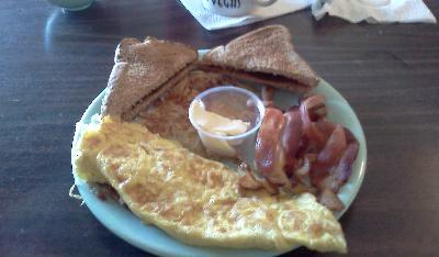
I ordered hot tea, and treated myself to a big breakfast: bacon, scrambled
eggs, hash browns and toast (with butter and jelly), and it was
still under $10. When I took a picture of my breakfast, the cook laughed,
Uh, oh, a food critic!
A barrel-chested guy came in and sat at the next table. Out of the
blue, he said, Tell me a story, so I told him about the first girl that
ever broke my heart. He seemed genuinely moved by my tale. I never got
his name. He traveled around the country in a truck. When he got tired,
he would pull off down some side road and go to sleep. He said in all the
years he camped out in deserts, he never saw a snake or a scorpion-- Except
for that one time I woke up drunk and found a coyote sniffing me. He chased
the coyote off by yelling, Im not dead! and the coyote casually loped
off into the brush
as if to say, I can wait. I asked the cook where
the bathrooms were, and he said, Under John Wayne. --And they were.
A portrait of Wayne hung over the door to the restrooms. Some German tourists
came in as I finished eating. Fast service, good food,reasonable prices,
and they let me camp for free -- you can't do much better than that.
I left a big tip. In the parking lot, a couple of dogs barked at me until
I said, Hey, Im a customer! They shut up and left me alone.
It was straight up 8 AM when I left the Bagdad Café. Down Route
66, I passed the RV park I almost stopped at, and almost missed the turn
to get on the interstate. It wasnt until I was back on I-40 that I realized
I needed to stop for gas. There was a gas station way back at Exit 18 but
I didnt think about that. I figured I had enough to get me to the next
town. The Sun was bright as I headed east. The landscape was littered with
lots of volcanic rocks. Eleven miles from Ludlow I passed a big lava field.
I made it to Ludlow, and spent $30 on some outrageously priced gas. The
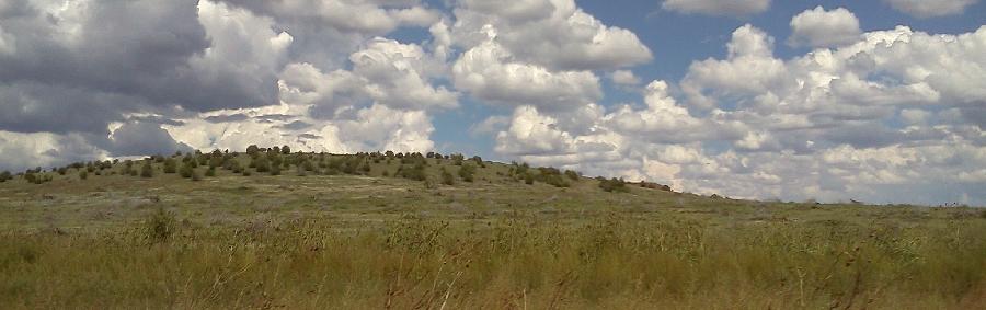
breeze felt nice in the shade. Down the road, the hills were scattered
with vegetation. Millions of years of evolution had produced plants that
could survive and flourish in the unforgiving Sonoran Desert. As scattered
as the plants were, the vistas were so vast that the valleys looked lush
in perspective. Dark, jagged mountains lay to the north. I found a Mexican
channel, and got to hear the news in Spanish. I could tell it was the news
because of the theme music. Two people on a 3-wheeled motorcycle passed
me.
 The shutter lag on my digital camera frustrated me. There were so many
pictures I knew Id have to delete once I got home. I crossed Fearless
Wash and saw more volcanic rocks. The John Wayne Safety Rest Area was closed
for repairs. Road signs were in miles and kilometers. At Mile Marker 126,
I came over a ridge and saw a vast valley down below. Signs warned truckers
to downshift. At Exit 133, I-40 makes a turn to the southeast. It was right
after 10 AM when I got to Needles, California. I stopped for some more
outrageously priced gas and left as soon as I could.
The shutter lag on my digital camera frustrated me. There were so many
pictures I knew Id have to delete once I got home. I crossed Fearless
Wash and saw more volcanic rocks. The John Wayne Safety Rest Area was closed
for repairs. Road signs were in miles and kilometers. At Mile Marker 126,
I came over a ridge and saw a vast valley down below. Signs warned truckers
to downshift. At Exit 133, I-40 makes a turn to the southeast. It was right
after 10 AM when I got to Needles, California. I stopped for some more
outrageously priced gas and left as soon as I could.
Just before 10:30, I-40 turned east again and crossed the Colorado
River. Except for not going where I wanted to go, I was making good time.
It was three hours to Flagstaff. I passed the exit for Lake Havasu and
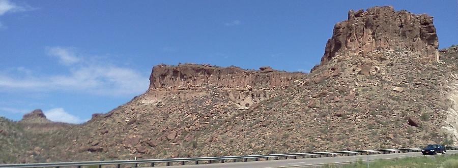
London Bridge, where I visited years past. Colorful mountains lined up
to the north. The Black Mountains of Arizona were why Interstate 40 made
it's little dip to the south. If it weren't for their craggy peaks, I-40
would go straight from Needles to Flagstaff. The highway steadily climbed
in elevation once I was on the Arizona side. It was interesting to watch
the changes in vegetation along the road. The scenery changed from desert
to wooded mountains. It was a pretty day. White clouds lounged across a
sharp blue sky. Ahead, the clouds looked darker. The weather application
on my smartphone predicted isolated thunderstorms in Flagstaff. As noon
approached, I saw cows grazing in brilliant green fields. A hundred miles
past Needles Id climbed almost 5,000 feet.
 Big drops of rain splattered my windshield for a minute. I decided to stop
in Seligman to get gas. I was not having any luck finding cheap gasoline
that day. The sky became overcast. Lush, green pastures separated gently
rolling hills. At Exit 144, I passed the hilltop RV park I missed headed
west one year. The air was very cool rolling into Williams. Someone from
Desert Rose called my cellphone to see about my visit. It seems I was there
so briefly, arriving late and leaving early, they werent sure I ever
showed up. It was rude of me to leave without saying goodbye, I realized,
and promised it wouldnt happen again.
Big drops of rain splattered my windshield for a minute. I decided to stop
in Seligman to get gas. I was not having any luck finding cheap gasoline
that day. The sky became overcast. Lush, green pastures separated gently
rolling hills. At Exit 144, I passed the hilltop RV park I missed headed
west one year. The air was very cool rolling into Williams. Someone from
Desert Rose called my cellphone to see about my visit. It seems I was there
so briefly, arriving late and leaving early, they werent sure I ever
showed up. It was rude of me to leave without saying goodbye, I realized,
and promised it wouldnt happen again.
I kept seeing cars that looked like they came from Burning Man. Up
ahead, there was a car loaded down with bicycles. I watched as it slowly
swerved over to the left, then swerved over to the right, and then swerved
all the way over into the inside laneright in front of a speeding semi
truck. The truck slammed on its brakes, the rig moaning at the strain,
wheels screeching, the air thick with the smell of burning rubber. I braked
and jerked over to the shoulder, certain the truck was going to plow into
that car, but at the very last moment the truck managed to slow down enough
to avoid a collision
But then, the car did nothing. It was like
the driver never noticed the doom that missed his back bumper by
inches. The truck was right on top of the car, and when the trucker blared
his horn, it must have sounded like a chorus of archangels at that distance.
The car swerved back to the outside lane and then pulled over to the shoulder.
Black smoke billowed from the truck as it zoomed on down the road. I glanced
over at the car when I passed it. The driver had a stunned look on his
face. He was lucky to have an alive look on his face.
It was a quarter to 2 when I got to Flagstaff. Gas prices were a lot
better than Californias. I stopped to top off the tank. That was when
the Sun came out. It was still cloudy, and storms lurked on the horizon.
It was an hour to Winslow, but I wasnt going to Winslow just yet. It was
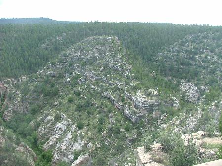
just after 2 PM when I took the turnoff for Walnut Canyon. There was a
rich scent of pine in the air. The visitor center was on the edge of the
canyon. I parked in the parking lot, changed into my boots and went inside.
One of the trails was closed, but most of the Island Trail was open. At
the top of the trail, signs reminded visitors they were at 6,690 feet elevation.
It was a 1-mile trail with 240 steps descending 185 feet. Whoa! Pace yourself!
a signed warned. Thunder rumbled in the distance.
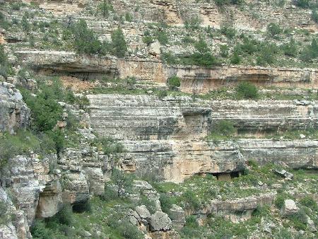
About a thousand years ago, a volcano erupted north of what is now Flagstaff,
Arizona. (Sunset Crater is what's left of the volcano.) Shortly thereafter,
local natives began building homes in the terraced walls of Walnut Canyon.
The natives who built homes into the walls of the canyon only lived here
for a hundred years or so before moving on. The dwellings lay pretty much
undisturbed until the late 19th century. Before the area was protected,
tourists looted and destroyed ruins looking for souvenirs. Priceless
artifacts that couldve enhanced our knowledge of ancient peoples probably
ended up collecting dust on some day trippers mantle, only to be thrown
away as junk by unknowing grandchildren. In 1915, Walnut Canyon was finally
declared a national monument.
| I was struck by the utter silence of the canyon. There was almost no
breeze. A couple of guys had me take their picture. I stayed close to the
cliffs as I walked down the steps. I could see ruins built into the rocks
of the opposite cliffs. Even though it was a steep drop, the ruins seemed
close enough to recognize faces. It wouldnt have been hard for neighbors
to call out to each other. The 240 steps took you to a landing, where there
were more steps down. The trail goes by a rocky overhang where a dwelling
used to be. |
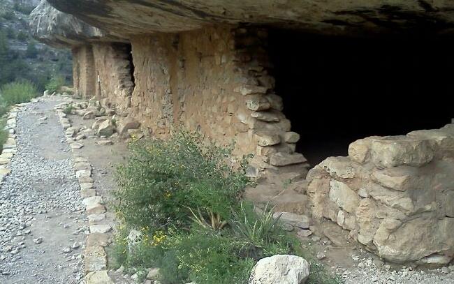 |
Further on, some solid walls remained intact. Down more steps, the trail
curved around to the sunny side of the island, where desert plants flourished.
Across the canyon, Ponderosa pines grew thick on the shady side of the
canyon. More steps led down to more ruins. A sign explained little windows
at the top of the walls helped with circulation. Out of respect, I didnt
go inside the ruins, but I could see the interiors varied from kitchenette
size to the area of a 2-car garage. I could tell I wouldve bumped my head
on the low ceilings. You could still see scorch marks where the natives
had their cooking fires. The rest of the trail was closed so I had to backtrack.
The sheer drops into the canyon took my breath away. It must have been
no big thing for the people who lived here. I guess the first thing everyone
learned was to watch your step. On the way back, I passed a family of four
taking pictures inside a ruin. I passed a British family, and then spoke
with two guys resting on a bench. They said it was a pretty day, and I
said the thunder earlier concerned me. Youre from Oklahoma you know
what thunder sounds like, one said. I got some stuff in the gift shop.
The clerk said she grew up in Arizona, but didnt visit the Grand Canyon
until she was 20 years old. She said, Never in your own back yard,
huh?
 It was going on 4 PM when I got back on the interstate. I drove out of
the Coconino National Forest just before Twin Arrows. One more mile, and
all the trees and brush were left behind for scrubby prairie. Winds rocked
the van. Down the road, I passed the rest area where I lost my toothbrush
one year. At 4:26, I passed Meteor City, but it did not look open. The
long fence that had a map of Route 66 was blown over. Twelve minutes later,
I pulled over into Winslow. The downtown area was clean and busy. The motels
seemed to be doing a brisk business. The two steel girders from the World
Trade Center had been relocated to a tidy rest area closer to town. I stopped
for supplies, then followed Highway 87 out of town and over the interstate
to Homolovi Ruins State Park.
It was going on 4 PM when I got back on the interstate. I drove out of
the Coconino National Forest just before Twin Arrows. One more mile, and
all the trees and brush were left behind for scrubby prairie. Winds rocked
the van. Down the road, I passed the rest area where I lost my toothbrush
one year. At 4:26, I passed Meteor City, but it did not look open. The
long fence that had a map of Route 66 was blown over. Twelve minutes later,
I pulled over into Winslow. The downtown area was clean and busy. The motels
seemed to be doing a brisk business. The two steel girders from the World
Trade Center had been relocated to a tidy rest area closer to town. I stopped
for supplies, then followed Highway 87 out of town and over the interstate
to Homolovi Ruins State Park.
 Camping was $18 a night. I found a site right next to the restrooms. Grasshoppers
were everywhere. I set up my stove and cooked supper: tomato soup, followed
by a can of fruit cocktail. There was a water faucet at my site so it was
easy to clean up. A park ranger stopped by and gave me a park brochure.
Have a pleasant evening, he said. The water in the showers was very hot.
It was breezy out. I got out my last working camp chair and sat in the
shade. I could see trucks on the interstate, but I was too far away to
hear them. Nearby, two guys worked under the hood of a car. There were
about a half dozen other campers in the park, some with big land yachts.
The Sun went down, and the stars came out. I drove 401 miles that day.
I still had miles to go.
Camping was $18 a night. I found a site right next to the restrooms. Grasshoppers
were everywhere. I set up my stove and cooked supper: tomato soup, followed
by a can of fruit cocktail. There was a water faucet at my site so it was
easy to clean up. A park ranger stopped by and gave me a park brochure.
Have a pleasant evening, he said. The water in the showers was very hot.
It was breezy out. I got out my last working camp chair and sat in the
shade. I could see trucks on the interstate, but I was too far away to
hear them. Nearby, two guys worked under the hood of a car. There were
about a half dozen other campers in the park, some with big land yachts.
The Sun went down, and the stars came out. I drove 401 miles that day.
I still had miles to go.

 Last updated: September, 2013