 I woke at 3:30 Arizona time. I think I slept for about 7 hours. The lights
were out, but the door outside was cracked open. I think one of my roommates
came back drunk and forgot to close the door. I closed it and dozed in
my bunk
I dreamed of a guy with webcams on his dog, so he could see
who his dog bit every day
I woke just before dawn Saturday morning.
It was cloudy out. I took a hot shower, and getting dressed, I made a racket
when a handful of coins fell out of my pants pocket. The other guys slept
right through it.
I woke at 3:30 Arizona time. I think I slept for about 7 hours. The lights
were out, but the door outside was cracked open. I think one of my roommates
came back drunk and forgot to close the door. I closed it and dozed in
my bunk
I dreamed of a guy with webcams on his dog, so he could see
who his dog bit every day
I woke just before dawn Saturday morning.
It was cloudy out. I took a hot shower, and getting dressed, I made a racket
when a handful of coins fell out of my pants pocket. The other guys slept
right through it.
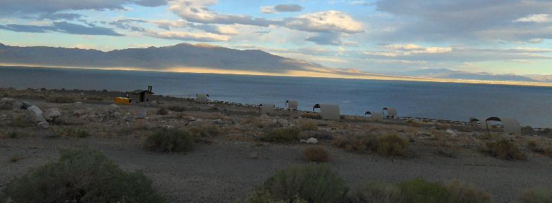
There was supposed to be a continental breakfast in the common area,
but the doors seemed to be locked. Thats when I realized there was a second
key along with my room key. There was a little K on it. It opened the
Kitchen door. I got there right before a brunette girl arrived to start
setting up the continental breakfast for everybody. I didnt catch her
name. We talked about the road construction that made it hard for me to
get there. She said the city started tearing up San Francisco Street, and
then another on the opposite side of the hostel Weve been getting it
from both sides, she said. I asked her how business was at the hostel.
She said it was their busy season. Weve been lucky that the last few
days have been pretty steady, she said, drawing her hand flat across her
face to illustrate steadiness. But yeah, its been insane. Breakfast
was toast with strawberry preserves, an orange and a hot cup of tea. Having
food and hot tea in me put things in perspective. I held the kitchen door
open for an elderly lady who was having trouble unlocking it. It took her
a while to figure out the K stood for kitchen. I thought it stood for
key, she explained. I said, But then, theyd all be marked that way.
 I took some pictures outside before packing up and hitting the road. The
roads were wet, the clouds a deep blue, but sharp beams of sunlight poked
through the stubborn clouds. The radio news reported bad floods in Pakistan.
I started to stop in Williams for some gas, but they were selling it at
$3.29 a gallon? No thanks. I got an overpriced fountain drink and
moved on. Id forgotten how amazingly beautiful the mountain passes were
in that part of Arizona. . In the higher elevations, the clouds hung very
low. At Devil Dog Road, I swerved to get around a cyclist on the road.
At Ash Fork, I passed the RV park I almost stopped for the night at once.
I took some pictures outside before packing up and hitting the road. The
roads were wet, the clouds a deep blue, but sharp beams of sunlight poked
through the stubborn clouds. The radio news reported bad floods in Pakistan.
I started to stop in Williams for some gas, but they were selling it at
$3.29 a gallon? No thanks. I got an overpriced fountain drink and
moved on. Id forgotten how amazingly beautiful the mountain passes were
in that part of Arizona. . In the higher elevations, the clouds hung very
low. At Devil Dog Road, I swerved to get around a cyclist on the road.
At Ash Fork, I passed the RV park I almost stopped for the night at once.
 |
Alongside the interstate, I could see an old railroad trailhead and
the remnants of Route 66. Wildflowers bloomed everywhere. I could see bushes
and small trees beside the road bowing to stiff crosswinds. At Seligman,
a sign warned Next Services 56 Miles. The persistent clouds hinted they
might be following me all day. I listened to an oldies radio station. |
The high winds pushed the clouds around, and huge shadows swept across
massive cuts in the hillsides. At Mile Marker 82, the road went over a
summit pass, and you could see for miles to the west. Two hours from Flagstaff,
I pulled over for a pit stop and to get some gas. The wind was relentless
as I stood at the gas pump. Gas was $2.79 a gallon. I told the guy at the
next pump I got spoiled in Flagstaff, where gas was 10 cents cheaper. When
you need it, you need it, he said.
 Crosswinds howled across the landscape. I watched a semi truck ahead of
me swerve all over the road, attacked by the wind. Just after 10 I got
to Kingman, A Community rich in History. I took Exit 48 and headed down
the long, lonely 4-lane Highway 93 towards Las Vegas. It looked like it
would be after dark by the time I got to where I was camping that night.
The radio station played Pinball Wizard.
Crosswinds howled across the landscape. I watched a semi truck ahead of
me swerve all over the road, attacked by the wind. Just after 10 I got
to Kingman, A Community rich in History. I took Exit 48 and headed down
the long, lonely 4-lane Highway 93 towards Las Vegas. It looked like it
would be after dark by the time I got to where I was camping that night.
The radio station played Pinball Wizard.
 Road construction started at Mile Marker 20. Thats where the road narrowed
to 2 lanes, but it looked like the widened road carved out of the rocks
would be opening soon. The winds were fierce through the scary mountains.
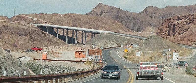
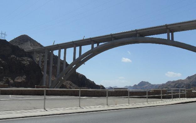
I could see the squiggly line of the Colorado River far below. When I went
over Hoover Dam, I could see the massive Hoover Bypass Bridge towering
above the gorge. Theyd been working on it pretty much the whole time Id
been traveling to Burning Man. The winds up there had to be harder than
the crosswinds Id endured all day. I could just imagine trucks being blown
off to their doom as soon as the bridge opened.
Road construction started at Mile Marker 20. Thats where the road narrowed
to 2 lanes, but it looked like the widened road carved out of the rocks
would be opening soon. The winds were fierce through the scary mountains.
I could see the squiggly line of the Colorado River far below. When I went
over Hoover Dam, I could see the massive Hoover Bypass Bridge towering
above the gorge. Theyd been working on it pretty much the whole time Id
been traveling to Burning Man. The winds up there had to be harder than
the crosswinds Id endured all day. I could just imagine trucks being blown
off to their doom as soon as the bridge opened.
 I finished the package of beef jerky Id been snacking on all morning.
Nevada time was the same as Arizona time. I came up behind a long line
of cars on the Nevada side of the dam, and it was bumper-to-bumper for
a few miles. Beyond the traffic jam, I rolled through Las Vegas, watching
the sprawl of the city sweep around me like a wave. Jet planes soared overhead.
At noon I could see the Strip just off the highway. A couple of minutes
later I turned onto Highway 95, headed northwest out of town.
I finished the package of beef jerky Id been snacking on all morning.
Nevada time was the same as Arizona time. I came up behind a long line
of cars on the Nevada side of the dam, and it was bumper-to-bumper for
a few miles. Beyond the traffic jam, I rolled through Las Vegas, watching
the sprawl of the city sweep around me like a wave. Jet planes soared overhead.
At noon I could see the Strip just off the highway. A couple of minutes
later I turned onto Highway 95, headed northwest out of town.
| I was on the open road headed for Indian Springs when I spotted a big
dust storm on the horizon, crawling along like a wounded leviathan, blowing
dust high into the sky. I got stuck behind a pair of huge RVs until I could
get around them.
At Indian Springs, I pulled off and got a Dr. Pepper at a roadside store.
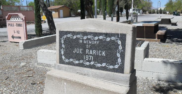
Down the road, I got out a roadside park in front of a weathered mobile
home park. Lunch was a tuna cup and my last hard-boiled egg. A sign in
front of the park declared In Memory of Joe Rarick. I reloaded film in
my camera and hit the road. By then, the wind was still constant and hard,
but it had turned hot, like air blowing out of a furnace. I had to fight
to keep the car on the road. A car with Maine license plates passed me. |
 |
 About 50 miles from Las Vegas the road went back to 2 lanes. A sign told
people to turn on their headlights for the next 51 miles. I was going through
the Armagosa Valley when I had to swerve to miss a huge grey tarantula
crossing the road. He looked as big as a dinner plate. The wind had been
making the wheels of my bicycle spin like crazy as I drove. I figured that
couldnt be good for the bike. Down the road, I stopped outside the truck
stop brothel to tie down the wheels with bungee cords. There were a bunch
of trucks and pickups with big trailers parked at the truck stop, waiting
for the winds to die down. (Or maybe they were waiting for friends at the
brothel; I don't know.) I could only imagine trying to put up a tent in
winds like that.
About 50 miles from Las Vegas the road went back to 2 lanes. A sign told
people to turn on their headlights for the next 51 miles. I was going through
the Armagosa Valley when I had to swerve to miss a huge grey tarantula
crossing the road. He looked as big as a dinner plate. The wind had been
making the wheels of my bicycle spin like crazy as I drove. I figured that
couldnt be good for the bike. Down the road, I stopped outside the truck
stop brothel to tie down the wheels with bungee cords. There were a bunch
of trucks and pickups with big trailers parked at the truck stop, waiting
for the winds to die down. (Or maybe they were waiting for friends at the
brothel; I don't know.) I could only imagine trying to put up a tent in
winds like that.
It was 29 miles to Beatty. That was where I stopped for gas at EddieWorld
($2.95 a gallon). I also got some postcards to mail from Black Rock City.
As I was pulling out of the parking lot, a truck pulling an Oliver trailer
pulled in front of me. The trailer had a solar panel on the roof. It looked
very much like a friend's trailer. I ended up following that trailer for
the better part of an hour. Outside of Beatty, the hot springs RV park
was still for sale. I wondered if Sixtoe was still running things.
 It was 92 miles to Tonopah. At least the winds seemed to die down a little.
I got stuck behind a rolling roadblock for several miles; it felt so good
when I finally got around that RV. I played music from my MP3 player. It
was playing Santa Esmeralda from the "Kill Bill" soundtrack when I crossed
the Esmeralda County line. I was on the Veterans Memorial Highway. There
were two trucks parked at the Goldfield Summit, for some reason. It was
a quarter to four when I got to Goldfield. I had just recently read that
Virgil Earp, Wyatt Earp's brother, passed away in Goldfield. I passed the
Green Parrot Saloon and the Dusty Fender. A political poster read Will
Rogers never met Harry Reid. There were many posters for Sharron Angle,
Reid's opponent in the upcoming election. (She lost.) The road west of
Goldfield stretched across a wide, slanted valley. I could see dark clouds
ahead.
It was 92 miles to Tonopah. At least the winds seemed to die down a little.
I got stuck behind a rolling roadblock for several miles; it felt so good
when I finally got around that RV. I played music from my MP3 player. It
was playing Santa Esmeralda from the "Kill Bill" soundtrack when I crossed
the Esmeralda County line. I was on the Veterans Memorial Highway. There
were two trucks parked at the Goldfield Summit, for some reason. It was
a quarter to four when I got to Goldfield. I had just recently read that
Virgil Earp, Wyatt Earp's brother, passed away in Goldfield. I passed the
Green Parrot Saloon and the Dusty Fender. A political poster read Will
Rogers never met Harry Reid. There were many posters for Sharron Angle,
Reid's opponent in the upcoming election. (She lost.) The road west of
Goldfield stretched across a wide, slanted valley. I could see dark clouds
ahead.
When I got to Tonopah, I noticed the winds had cooled things off a little.
That wasnt necessarily good: a chilly breeze meant rain was coming. The
Sun had begun its slow creep towards the western horizon. Outside of town,
I stopped at Millers Rest Area. I made a pit stop and filled up my canteens.
It was very windy. There was a big shaded area with green grass, which
I thought might work as a campsite, with the restrooms as a windbreak,
but I realized it was green because of the sprinklers that went
off automatically every night. Anybody camping there would get soaked.
 The one place in the rest area that allowed camping was way off to the
side, basically a parking lot of bare, rocky earth, with no windbreaks.
Camping there in anything other than an RV would be a terrible idea.
The one place in the rest area that allowed camping was way off to the
side, basically a parking lot of bare, rocky earth, with no windbreaks.
Camping there in anything other than an RV would be a terrible idea.
 Air-borne dust stung my eyes. Back on the highway, big RVs were being blown
around by the wind like big toys. Eight miles from Mina, I passed Graffiti
Junction. I still dont know what the heck it was supposed to be. Mina
was where the grocery store had a BURNINGMAN WELCOME sign out front. It
was 40 miles to Hawthorne. A sign in Luning warned Strong Crosswinds Possible.
Possible?
Air-borne dust stung my eyes. Back on the highway, big RVs were being blown
around by the wind like big toys. Eight miles from Mina, I passed Graffiti
Junction. I still dont know what the heck it was supposed to be. Mina
was where the grocery store had a BURNINGMAN WELCOME sign out front. It
was 40 miles to Hawthorne. A sign in Luning warned Strong Crosswinds Possible.
Possible?
At 6 PM Walker Lake came into view. The Oliver Id been following was
parked beside the highway with a couple other RVs. The speed limit in Hawthorne
was 25 MPH. I took it easy until I could get to the Safeway store. I spent
$22 on dinner rolls, fresh fruit, tomatoes, Fritos and beer. I passed a
sheriffs patrol car leaving town, parked near a very comfortable-looking
RV park. The Sun was just falling behind the mountains. The angle of the
light turned grassy yards a luminous emerald green. I slowed down to look
at the lake, which was beautiful in the evening light. I also looked over
the Sportsmans Beach campsite on the banks of Walker Lake. No water, no
shade, nothing to protect a flimsy tent from the constant winds. No place
for anything but a sealed RV. I moved on.
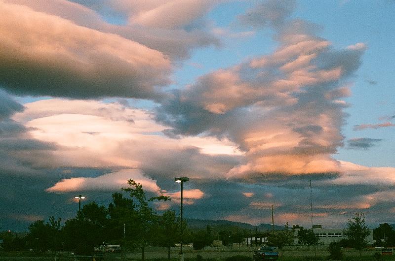
 There were four police cars lined up beside the road on the other side
of the lake. It was getting dark in the east, but highlighted with some
amazing lenticular clouds. Right after 7 PM, I turned west towards Yerlington.
The last sunlight disappeared behind dark purple mountains and cobalt blue
clouds. I stopped for $10 worth of gas as I watched lightning flash up
towards the north, where I was headed. I turned the car north.
There were four police cars lined up beside the road on the other side
of the lake. It was getting dark in the east, but highlighted with some
amazing lenticular clouds. Right after 7 PM, I turned west towards Yerlington.
The last sunlight disappeared behind dark purple mountains and cobalt blue
clouds. I stopped for $10 worth of gas as I watched lightning flash up
towards the north, where I was headed. I turned the car north.
 It was dark when I turned down the Fir Avenue entrance to the Lahontan
Recreational Area. I later learned it was called "the Silver Springs side."
I stopped at the ranger station. The doors were closed, bur there were
still lights on inside. I put my $7 camping fee in the box and headed for
compound 7. The road was dark and twisty. I found the familiar clump of
trees, where Id camped before, but I was looking for the bathrooms. I
had the idea of filling up my water jugs that night in order to save time
in the morning. I spotted the lights around the bathrooms, up on a little
hill, but I missed the turnoff for it. I was tired and hungry and probably
not thinking straight. There was a road that circled the bathrooms along
the base of the hill, so I figured Id just circle around.
It was dark when I turned down the Fir Avenue entrance to the Lahontan
Recreational Area. I later learned it was called "the Silver Springs side."
I stopped at the ranger station. The doors were closed, bur there were
still lights on inside. I put my $7 camping fee in the box and headed for
compound 7. The road was dark and twisty. I found the familiar clump of
trees, where Id camped before, but I was looking for the bathrooms. I
had the idea of filling up my water jugs that night in order to save time
in the morning. I spotted the lights around the bathrooms, up on a little
hill, but I missed the turnoff for it. I was tired and hungry and probably
not thinking straight. There was a road that circled the bathrooms along
the base of the hill, so I figured Id just circle around.
And thats when everything went to hell...
Original content (c)opyright 2010 by Tim Frayser
|
If your image appears on this site, and you'd
rather it didn't, drop me a line and I'll remove it. Pictures appearing
on this website are for personal use and are not for sale.
|
|
Links: Hoover
Dam Miller's
Rest Area
|
BurningClam.Com