 I woke up just after 6, New Mexico time. I figure I slept about 9 hours.
The Sun was not quite up yet. I took a hot shower. It was 56 degrees out
Thursday, September 6th. I had to figure out where I was going to sleep
that night. I had two choices: I could spend the day at Chaco Canyon, and
try to spend the night there, or visit the canyon and then find someplace
to crash closer to home. There was a number to call for road conditions
to the canyon, but all I got was a recording that there was construction
ongoing in the park. I decided to go for it.
I woke up just after 6, New Mexico time. I figure I slept about 9 hours.
The Sun was not quite up yet. I took a hot shower. It was 56 degrees out
Thursday, September 6th. I had to figure out where I was going to sleep
that night. I had two choices: I could spend the day at Chaco Canyon, and
try to spend the night there, or visit the canyon and then find someplace
to crash closer to home. There was a number to call for road conditions
to the canyon, but all I got was a recording that there was construction
ongoing in the park. I decided to go for it.
 |
Out of what cash I'd started out with, I had just over 1/6th left.
Satori's oil level was good. I policed the room, loaded up the car, and
filled my water bottles. The motel was on a tricky intersection. I took
no chances and circled around until I could head east safely. I needed
to follow Highway 64 to Bloomfield, then turn south on Highway 550. |
I stopped for gas at a station across the street from the Wonderful Buffet.
A sign at one fast food place declared The peach shake is back! The slogan
at the Taco Boy restaurant was Taco bout good! There was a chill
in the air as I got $20 worth of gas. I almost got out the hoodie. It was
nine miles to Bloomfield, where I almost missed the turn south. It was
a nice 4-lane with wide shoulders. I passed a bunch of much fancier motels
and an RV park that seemed to be right on the banks of the San Juan River.
There were some high clouds, but I figured theyd burn off as the day wore
on. Traffic was pretty steady; there were lots of pickups and trucks, almost
no cars. I passed the Blanco Trading Post right before 9; it looked closed.
The ground alongside the highway was all dug up for a pipeline. The Nageezi
Trading Post also looked closed. The turnoff was three miles away.
| When I made the turn, a sign said the visitor center was 21 miles away.
There were lots of colorful rock outcroppings that reminded me of the Painted
Desert. Wildflowers lined the road. The landscape was sage and tenacious
scrub brush. Life kept a stubborn grip on the land. It was just a narrow
asphalt road, but four miles in lines appeared in the middle of the road.
A couple of little farm houses were scattered here and there, sometimes
with a traditional Navajo hogon. |
 |
Eight miles from the highway, the pavement ended and turned into a dirt
road. Only, it wasnt just dirt: it was a hard-packed, washboarded, craters
of the Moon bumpy road. I had to slow way down to almost 10 MPH just to
keep the van from shaking apart. I wasnt in any hurry. A local pickup
started coming down the road towards me just as I noticed a black SUV behind
me. This place sure got crowded all of a sudden, I thought. When
the SUV with Texas plates rolled past me, I thought maybe the road wasnt
as bad as I thought, but the road proved me wrong when I tried to speed
up. Five miles down the dirt road, a sign said the speed limit was 35.
Ha! I was in open range, and a couple of cows looked at me with
disinterest as I bounced past. I kept thinking, I must really
want to get to this place.
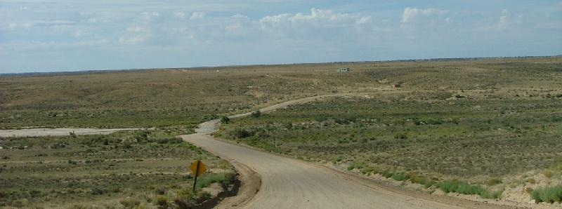 Around a curve, I passed a New Mexico DOT truck parked alongside the road.
Finally, the gate to the park appeared, and I was back on smooth pavement
again. It took me 54 minutes to go 13 miles of dirt road. It was 2 ½
miles to the visitor center. On the way, I passed the campground, which
had its own ruin. Majestic Fajada Butte came into view, and I pulled into
the visitor center parking lot. Bathrooms were my first priority.
Around a curve, I passed a New Mexico DOT truck parked alongside the road.
Finally, the gate to the park appeared, and I was back on smooth pavement
again. It took me 54 minutes to go 13 miles of dirt road. It was 2 ½
miles to the visitor center. On the way, I passed the campground, which
had its own ruin. Majestic Fajada Butte came into view, and I pulled into
the visitor center parking lot. Bathrooms were my first priority.
 When I walked inside, I had my camera over my shoulder. Someone said, Theres
somebody ready for Chaco Canyon! I paid my fee, and the nice ranger lady
gave me tips on exploring the canyon. I mentioned spending the night in
the campground, and she said there were sites still available. There was
even a planned lecture at sunset. It was something to ponder. Right behind
the center was a trail over to Una Vida, an unexcavated great house that
was at least two stories tall and had 124 roomsthey think, because Una
Vida remains much as it was when it was first discovered: half-buried.
The park leaves it the way it is to show what an unexplored ruin looks
like.
When I walked inside, I had my camera over my shoulder. Someone said, Theres
somebody ready for Chaco Canyon! I paid my fee, and the nice ranger lady
gave me tips on exploring the canyon. I mentioned spending the night in
the campground, and she said there were sites still available. There was
even a planned lecture at sunset. It was something to ponder. Right behind
the center was a trail over to Una Vida, an unexcavated great house that
was at least two stories tall and had 124 roomsthey think, because Una
Vida remains much as it was when it was first discovered: half-buried.
The park leaves it the way it is to show what an unexplored ruin looks
like.
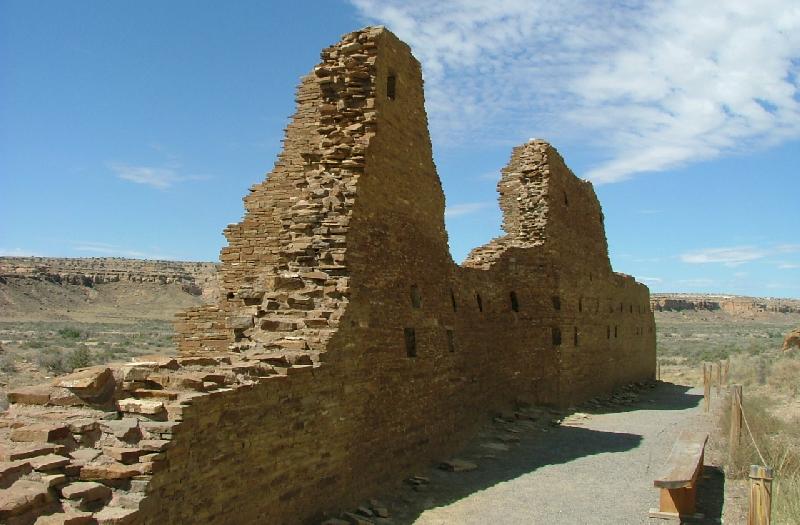
 The remains of dozens of great houses are all over Chaco Canyon, and roads
lead from them to more than 150 smaller houses in the area. The Una
Vida wall that was exposed was bulging out, and looked dangerously unstable.
Signs tell everybody to not climb on the walls, and probably not because
they're being proactive. Finger-size lizards skittered out of the way,
and I passed ant hills a yard wide.
The remains of dozens of great houses are all over Chaco Canyon, and roads
lead from them to more than 150 smaller houses in the area. The Una
Vida wall that was exposed was bulging out, and looked dangerously unstable.
Signs tell everybody to not climb on the walls, and probably not because
they're being proactive. Finger-size lizards skittered out of the way,
and I passed ant hills a yard wide.
| The mile-long trail takes you past Una Vita and up to the stone cliffs
overlooking the great house, where there are petroglyphs. I was sucking
air as I climbed to the base of the cliffs, and suddenly, there they were,
about 15 feet up on the cliff face. One set of pictures had a precarious
ledge the artist could have maybe balanced on, but that was it. There was
some nice shade up near the cliffs, but I knew it wouldnt last. The hike
down was a lot easier. |
 |
I got in the van and started driving road around the canyon. Off to the
right, I could see the ruins of Kin Nahasbas, built in the 9th or 10th
Century, which was not open to the public. There was a bike rack in the
little parking lot when I stopped at Hungo Pavi. The park encourages people
to explore the canyon on bikes, just not on the trails.
 The trail at Hungo Pavi led right into rooms and around the back wall.
The cliffs behind the great house are very close. As I drove to the next
ruin, I noticed a steep, narrow gulch running the length of the canyon.
It did not look easy to cross on foot. It served to explain why most of
the buildings were on the north side.
The trail at Hungo Pavi led right into rooms and around the back wall.
The cliffs behind the great house are very close. As I drove to the next
ruin, I noticed a steep, narrow gulch running the length of the canyon.
It did not look easy to cross on foot. It served to explain why most of
the buildings were on the north side.
I stopped at the next parking lot and took the trail up to Chetro Ketl.
Many cars were already parked there. Brochures were available for borrowing,
so I read as I went. Some kind of animal scurried into the brush as I climbed
the trail. Part of the house was left unexcavated. Pieces of wall material
lay scattered everywhere. Some of the wall was red, and the brochure said
that happens when the stones are burned. They didnt know why. Originally
it had about 140 rooms and covered three acres. Part of it is elevated,
in that tons of rock were hauled in to build it higher. One south wall
had a row of windows that looked like they had been bricked up.
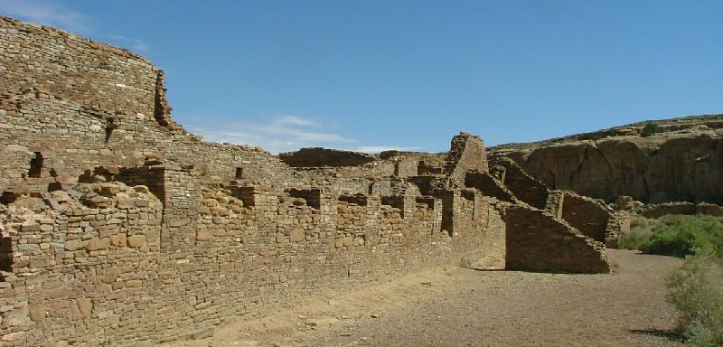 The great kiva was huge, and there were other, smaller kivas. I was impressed
with some round windows that reminded me of medieval loopholes, and what
looked like an figure-8-shaped kiva. Supports have been added to help hold
the walls together. Between the cliff walls and Chetro Ketl is a smaller
group of buildings called the Talus Unit. It reminded me of servants quarters,
or maybe a spare house where the in-laws lived.
The great kiva was huge, and there were other, smaller kivas. I was impressed
with some round windows that reminded me of medieval loopholes, and what
looked like an figure-8-shaped kiva. Supports have been added to help hold
the walls together. Between the cliff walls and Chetro Ketl is a smaller
group of buildings called the Talus Unit. It reminded me of servants quarters,
or maybe a spare house where the in-laws lived.
| There was a trail that ran long the canyon wall from Chetro Ketl to
Pueblo Bonito. Along the way, there were petroglyphs carved into the stone.
A fence keeps tourists from getting too close.
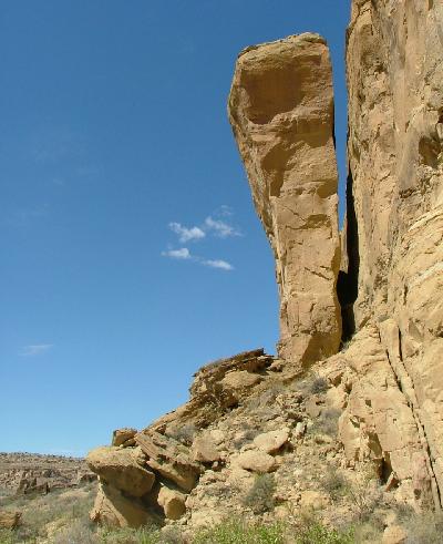
Along the way, I was impressed with a huge honking rock slab, as big
as a house, balanced on its edge next to the cliff face. I wondered if
anyone worried about it falling over
because it wouldnt be the first
time.
There used to be a rock just like it called, appropriately, Threatening
Rockright behind the biggest of Chaco Canyons great houses, Pueblo
Bonito. In 1941, the rock did indeed fall over, crushing about 60
rooms. The petroglyph trail takes you right up to where Threatening Rock
fell, and gives you and overview of the massive structure. |
 |

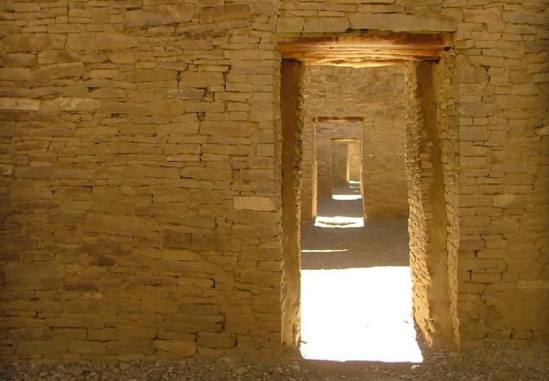
Pueblo Bonito had about 650 rooms, and maybe as many as 800, each of
them at least as big as the smallest apartment I ever lived in. There were
several other tourists walking among the ruins. I came across an old man
sitting in the shade of an ancient wall; he moved along with he saw me.
Most of my visit, it looked like I was the only one there, my footsteps
the only sound.
 The whole place just went on and on. Walking around the smaller kivas,
I tried to imagine thousands of people living here, going about their daily
chores, cooking and cleaning and tending stock. Thick, wooden beams shore
up vulnerable walls. I stood on the edge of the great kiva, and wondered
about the wedge-shaped spaced around the kiva walls. What were those little
rooms used for?
The whole place just went on and on. Walking around the smaller kivas,
I tried to imagine thousands of people living here, going about their daily
chores, cooking and cleaning and tending stock. Thick, wooden beams shore
up vulnerable walls. I stood on the edge of the great kiva, and wondered
about the wedge-shaped spaced around the kiva walls. What were those little
rooms used for?
The trail took me down into the rooms themselves. The doorways were
only waist-high in some places. Inside, I looked up at what would have
been three floors of apartments above me. The place had hundreds of rooms
like that. Some rooms had windows into other rooms; I imagined families
using them to share food and to just sit and talk. Outside was a guy with
a camera and tripod. He was already there when I arrived. I asked, Get
any good ones? Hope so! he said.
 The road branched off and took me over to Pueblo Del Arroyo. There was
some climbing to get into the ruins, but once inside it took me all around
and through the rooms. There is a good view of the South Gap between West
Mesa and South Mesa. Some guys from Texas, I think, were touring the ruins.
This was condo living a thousand years ago, one commented. I looked at
what the brochure called the unique tri-wall structure of the kiva. The
concentric circles reminded me of the spiral patterns so often seen in
Native American petroglyphs. Was there a connection?
The road branched off and took me over to Pueblo Del Arroyo. There was
some climbing to get into the ruins, but once inside it took me all around
and through the rooms. There is a good view of the South Gap between West
Mesa and South Mesa. Some guys from Texas, I think, were touring the ruins.
This was condo living a thousand years ago, one commented. I looked at
what the brochure called the unique tri-wall structure of the kiva. The
concentric circles reminded me of the spiral patterns so often seen in
Native American petroglyphs. Was there a connection?
 Back in the parking lot, a couple from Missouri remarked at the dust still
all over Satori. Looks like youve been down the same kind of roads we
have, they said. I crossed a small bridge and stopped at Casa Rinconada,
one of the few ruins on the south side of the canyon. That was also the
trailhead for a path leading up to Tsin Kletsin, the 81-room house on top
of the South Mesa. For that you need a backcountry permit, but the permits
are free, and the park provides permits for you to fill out right at the
parking lot. I had not planned on hiking the loop trail, since it takes
up to three hours, so I just explored Casa Rinconada. There were several
buildings, all leading up to a great kiva that sits elevated on a little
hill. The 63-foot diameter kiva is almost perfectly round, and on the summer
solstice the Sun shines into one particular niche in the wall. In addition,
there is a 39-foot long tunnel dug out of the sandstone running under the
kiva, its purpose unknown. I stood outside the kiva and looked north to
Pueblo Bonito. It was less than a mile away, the features very distinct.
If the people who lived here knew what window to look at, they could have
easily waved to their friends.
Back in the parking lot, a couple from Missouri remarked at the dust still
all over Satori. Looks like youve been down the same kind of roads we
have, they said. I crossed a small bridge and stopped at Casa Rinconada,
one of the few ruins on the south side of the canyon. That was also the
trailhead for a path leading up to Tsin Kletsin, the 81-room house on top
of the South Mesa. For that you need a backcountry permit, but the permits
are free, and the park provides permits for you to fill out right at the
parking lot. I had not planned on hiking the loop trail, since it takes
up to three hours, so I just explored Casa Rinconada. There were several
buildings, all leading up to a great kiva that sits elevated on a little
hill. The 63-foot diameter kiva is almost perfectly round, and on the summer
solstice the Sun shines into one particular niche in the wall. In addition,
there is a 39-foot long tunnel dug out of the sandstone running under the
kiva, its purpose unknown. I stood outside the kiva and looked north to
Pueblo Bonito. It was less than a mile away, the features very distinct.
If the people who lived here knew what window to look at, they could have
easily waved to their friends.
 What was it like to live in Chaco Canyon, at the center of commerce for
a native culture? Chaco Canyon used to be a big player in pre-Columbian
America. Today, it's not near anything. A major highway doesn't even come
near it. It's a humbling lesson in just how tenuous and fragile "a major
center of commerce" could be. I listened to my footsteps on the gravel
trail as I made my way back to Satori. I stopped, and marveled at the silence
but then, it wasnt completely silent. I listened closely, and heard the
buzzing of a bug, the skitter of a lizard, the soft rustle of the breeze
through the scattered trees. It was the absence of human-made soundsthe
rumble of an engine, the hum of an air conditionerthat made me associate
it with silence.
What was it like to live in Chaco Canyon, at the center of commerce for
a native culture? Chaco Canyon used to be a big player in pre-Columbian
America. Today, it's not near anything. A major highway doesn't even come
near it. It's a humbling lesson in just how tenuous and fragile "a major
center of commerce" could be. I listened to my footsteps on the gravel
trail as I made my way back to Satori. I stopped, and marveled at the silence
but then, it wasnt completely silent. I listened closely, and heard the
buzzing of a bug, the skitter of a lizard, the soft rustle of the breeze
through the scattered trees. It was the absence of human-made soundsthe
rumble of an engine, the hum of an air conditionerthat made me associate
it with silence.
I wondered about the people who lived here, and how it must have broken
their hearts to leave. I wondered what did the last Chacoan think as he
looked over his shoulder at the home of his fathers as it faded into the
distance... As it turns out, however, that's not how it happened. Ancient
peoples were not married to the land like modern people are, and when it
got too hard to live in Chaco Canyon, the people moved away-- but not in
a mass exodus, but slowly, groups and families at a time. There are Native
American families all across the Southwest with oral histories that trace
ancestors back to Chaco Canyon.
 The clouds were amazing all day, like big, fluffy white puppies playing
on a blue carpet. I drove back to the visitors center. Inside, there were
only a couple more names in the guest book after mine. The gift shop was
very happy to see me as I got gifts for people back home. I decided Id
seen all I wanted to see that day. I didnt see everything in Chaco Canyon,
and that didnt bother me at all; it just gave me something to look forward
to next time, for I knew I would someday return.
The clouds were amazing all day, like big, fluffy white puppies playing
on a blue carpet. I drove back to the visitors center. Inside, there were
only a couple more names in the guest book after mine. The gift shop was
very happy to see me as I got gifts for people back home. I decided Id
seen all I wanted to see that day. I didnt see everything in Chaco Canyon,
and that didnt bother me at all; it just gave me something to look forward
to next time, for I knew I would someday return.
| Outside, I heard a loud noise, and a big raven, as big as my forearm,
stood on a nearby picnic table. An arriving park ranger said that if I
waited long enough, Id see him attacking the trash cans. Theyve figured
out how to open them, she said. Other tourists were gathering in the parking
lot, preparing to leave. I held back and let them go on ahead. It was just
after 2 PM when I left the visitors center.
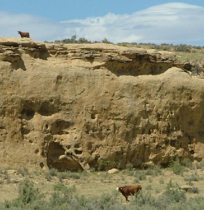
Past the campground, I noticed some cows moving along the ridge
and
a lone cow following along on top of the ridge. Somehow, shed gotten separated
from the herd back where the ridge merged at ground level, and was trying
to keep up, but every step just took her further into danger. I hoped she'd
be all right. |
 |
I hit the dirt road again, and slowed down for a bumpy ride again. I remembered
some smooth parts of the road, where I could speed up to, whoa, 35 MPH,
but then Id hit a rough spot and have to slow down again. I didnt want
a blown tire. The slow-going at least let me admire the landscape. The
DOT truck was right where I passed it that morning. Several vehicles passed
me coming and going, even a car from Oklahoma, and I figured Id better
get my shock absorbers checked once I got home. It took about an hour to
get back to pavement, and the dirt road was like riding in a washing machine
right up to the last foot. Once I got to asphalt, everything was smooth
sailing. I got back to Highway 550, and passed a Red Man Express gas station
as I turned south.
Rocky, colorful hills lined the way. Twelve miles down the road, I topped
a 7,000-foot summit at mile marker 102, and Satori did very well. There
were several more summits for the next half hour until I crossed the Continental
Divide just after 4 PM. I looked for a gas station when I got to Cuba,
and settled on a Circle K store. Thats where I got $20 worth of gas. The
smartphone reported no phone network so I couldnt call home just yet.
It was 63 miles to Bernalillo. Just outside of town, Satori clicked over
277,000 miles.
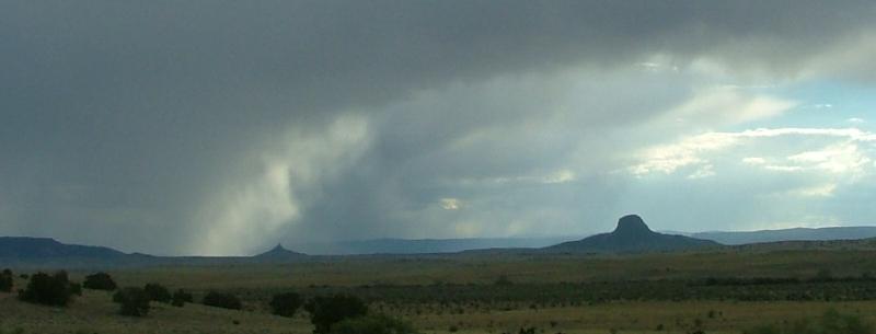 It looked like rain ahead. There were some clouds forming over a pair of
buttes off to the west. I found a Mexican station on the radio. The sky
darkened, and gusty winds really started to blow. I hadnt eaten all day,
so I was pretty hungry by then, but particularly Id been hungry for a
Wendys hamburger. As I pulled into Bernalillo, I was passing the Enchanted
Hills Shopping Center when I saw a Wendys up aheadbut, it was situated
on a corner where I couldnt get to it. Location fail.
It looked like rain ahead. There were some clouds forming over a pair of
buttes off to the west. I found a Mexican station on the radio. The sky
darkened, and gusty winds really started to blow. I hadnt eaten all day,
so I was pretty hungry by then, but particularly Id been hungry for a
Wendys hamburger. As I pulled into Bernalillo, I was passing the Enchanted
Hills Shopping Center when I saw a Wendys up aheadbut, it was situated
on a corner where I couldnt get to it. Location fail.
I got on Interstate 25 and headed south. It was 39 miles to Albuquerque.
Minutes later, I got some sprinkles, that came and went the whole journey
down I-25. The wind picked up even more. I turned onto Interstate 40, and
found myself stopped in a big traffic jam. There was an accident in the
inside lane up ahead, and traffic was having to be funneled around it.
I took a wrong turn and ended up on Coors Avenue. I was looking for a way
to turn around when.. there was a Wendys! When I tried to change lanes,
I was almost sideswiped by a guy in a pickup more interested in his Ipod
than driving, but I managed to get off the road and get my cheeseburger.
Halfway through my meal, I realized I was in a much better mood. It was
the first real food Id had all day.
I picked up some beer at the drug store across the street and headed
back to the interstate. I exited about 10 miles down the road and pulled
in at the High Desert RV Park. The lowest rate Id seen was $17 a night,
but since I was dry camping with no hookups, they only charged me $10
to camp. They put me in spot 203, right in front of the office. I took
a hot shower and called home. I only drove 252 miles that day; it seemed
a lot longer. I uploaded a picture to Facebook just in time, because the
local network connection went away after dark. It was very windy, and lightning
flashed in the distance. Above, an American flag flapped straight out from
the flagpole. The office had a nice lounge to sit and write, but it closed
after dark, too. I had a beer in the back of the van and listened to my
MP3 player, which I found in my first aid kit, of all places. I bundled
up in the back and had no trouble falling asleep.

 Last updated: September, 2012
BurningClam.Com
Last updated: September, 2012
BurningClam.Com