 The Journey East: Black Rock City to Provo
| I was up just before dawn Monday, September first, the early morning
clouds deep purple against the lightening sky. The storm put all my plans
on hold. My original plan was to get a few hours sleep after the Temple
burn, then get up about 4 AM to beat the rush of people out of the city.
If it was like 2006, I imagined a madhouse: miles of exiting cars lined
up for hours trying to get out. On the other hand, the overnight storm
probably threw everyone's schedule off, too. It was possible I had a window
of opportunity before the mass Exodus began. I decided to make a break
for it. |
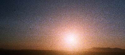 Sunrise over the Nightengale Mountains.
|
The rebar I'd staked the tent down with came out easily. The rainfly was
tied to the tent, but I'd also staked it down with ropes connected to two
regular aluminum tent stakes... and they refused to come up out of the
ground. I pulled and twisted, but they wouldn't budge. I needed a pair
of vice grips, but I hadn't packed anything like that. Rusty loaned me
a pair of pliers. The Sun slowly inched up over the playa. My hands were
stiff and the skin was raw from pulling. I wished I'd brought a shovel.
I pulled and tugged with all my might, and they finally popped out of the
hard ground. Once the tent was loose, I didn't bother folding it up. I
just piled it all in the back of Satori. I was so frantic to get moving,
I didn't even hook up the bike rack. I just threw it and the bicycle in
the back with everything else. I had to go. At about 6:38 local time, I
said my goodbyes to those few that were awake and pulled out of camp. Vehicles
were moving down the streets. Moving was good.
As I came up to the DPW donation station, I pulled over and took out
the beer nobody wanted at the bar. Yay, beer! smiled the guy at the station.
Merry Christmas! I said. Happy Hanukkah! he replied. Traffic was light
as I passed the Greeter's station. Crossing the playa, I passed dozens
of traffic cones, strewed haphazardly across the lanes. That told me nobody
had been out to set them up yet, and the Sun was already up. Satori's temperature
gauge was optimal, but much hotter than normal. I didn't see any Exodus
crew until I got to the Gate. Beyond there, cones had been set up for six
lanes of traffic in straight, regular lines. Traffic stopped as vehicles
bottlenecked ahead. Four lanes of traffic merged into three, then two,
then one. As I reached the 2-lane gravel road, I finally saw a flagger
with a reflective vest. We were already in one lane of traffic, but he
was motioning for people to go into both lanes of the gravel road--
which was dangerous, because vehicles were entering by way of the inbound
lane! That was useless. I was listening to BMIR on the radio. After 45
minutes of music, Bobzilla came on. He reported there was "no wait at the
Gate." A flagger at the highway stopped me for a passing car, then waved
me on. I'd made my Exodus. Fifty-six minutes from camp to pavement? I'll
buy that for a dollar!
The air was crisp, but I had the windows cracked open as I went through
Gerlach. Bobzilla reported that the temperature was 36 degrees outside!
That meant it must have been close to freezing when I got up. The road
out of Gerlach was open and empty. The Sun rose over the Nightingale Mountains
as I headed south. Every few miles, I passed some Burner cars parked alongside
the road-- early risers that beat the rush. A couple of the local Indian
taco stands were already open, and doing a popular business. Ten miles
out of Nixon, my cellphone came alive. I had messages from friends back
home.
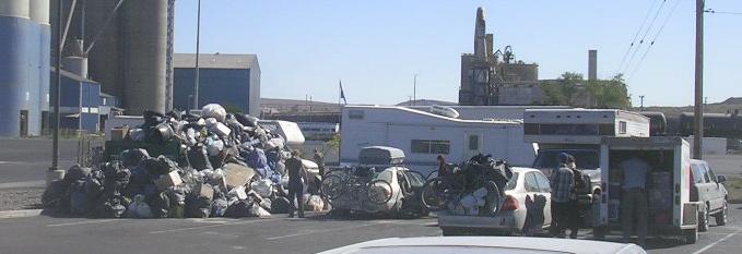 |
At Fernley, I pulled over into the truck stop parking lot where I'd
made my LiveJournal post before the event. The place was packed with Burner
vehicles. A special large dumpster had been provided for Burner trash;
it was already overflowing with garbage.
A sweet Burner lady came by and gave me a gift of a Burning Man sticker.
I returned the favor with a spare bandanna. Such a nice gesture! |
I went inside and washed up in the bathroom. In the mirror, I looked like
a dirty hippie. Wait a minute... I was a dirty hippie! There
was an Arby's at the truck stop, so I treated myself to one of their big
sandwiches. I only ate half, so that I'd have something for later. I got
some souvenirs and $20 worth of gas, and then hit the road again. This
time, I headed into unknown territory. I got on the interstate, headed
east. The wide, Interstate 80 was almost clean of traffic. It had turned
into a beautiful day.
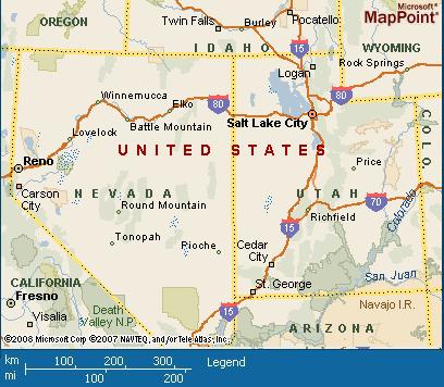
| The route from Fernley east towards Salt Lake City was not completely
unfamiliar to me. I traveled it in 2006. The difference was, this time,
I was driving my car instead of riding in a train. The train tracks follow
the route of the original transcontintal railroad. I didn't realize that
when I rode the California Zephyr back in 2006. The road east goes across
the 40-Mile Desert and the Humbolt Sink. |
 |
The signs said it was two hours to Winnemucca. Strong crosswinds blew
from mountains of purple and rusty yellow. "Road gators" --pieces of blown
tires-- littered the highway. Chunks of rubber flew from the back of a
semi I passed. The road must be hard on tires, I figured. Cars and trucks
from Burning Man passed me, marked by their deep loads of gear and fuzzy
bicycles. As soon as I hit the interstate, Satori's temperature gague went
back to normal. She flew down the road, purring like a kitten. In the news,
Hurricane Gustav was moving in from the Gulf of Mexico. Yet another
hurricane was assaulting New Orleans. I passed fields of freshly cut hay,
stacked in bales.
Lovelock was full of casinos and motels, and not much else that I could
see. I continued eastward. Nevada has a raw beauty to it, harsh yet vibrant.
There were lots of Burners on the highway. Just after noon Nevada time,
I stopped at a little truck stop in Puckerbrush, Nevada, population 28.
Nowhere near Route 66, the truck stop nevertheless sold Route 66 neon clocks.
Down the road, I pulled off the highway at Winnemucca. I thought about
visiting the train station where we'd stopped during my 2006 trip, but
it just wasn't that important to me. I found the Wal-Mart instead. I got
film and another disposable camera. The SLR camera's batteries had run
down. I stopped for some gas ($3.79 a gallon), a Dr. Pepper, and
some beer for later. There were other Burners at the gas station. I knew
because they had put tape all over the Budget Rental truck until it read
Fudget. There was a sign commemorating the Winnemucca to the Sea highway,
a route linking northern Nevada with the California coast.
 Down the road, farms and ranches appeared alongside the highway. Valleys
turned greener. Northern Nevada seemed a little more... domesticated than
the rugged south. The rest areas along the highway looked full of big trees
and very comfortable. Dark, volcanic outcroppings appeared along a southern
ridge. I ate the other half of my Arby's sandwich. I drove through a dramatic
cut in the Earth to the Golconda Summit at Exit 200, passing trucks struggling
to get up the grade. Five miles on, I passed the exit for Pumpernickel
Valley. More Burners passed me, waving as they went. Everyone seemed to
be in a much bigger hurry than me that day. Just after 2 PM Nevada time
I made it to Battle Mountain, "gateway to Nevada's outback." I still had
300 miles to go to Salt Lake City. I found a radio station playing a biography
of Eric Clapton. A sign warned of a dust hazard ahead. Ha! What
do they know about dust hazards? I went through lush, pretty valleys as
the road took me into grassy, rolling hills. I was somewhat reminded of
the golden foothills of the Sierra Nevadas. Exit 268 took me over Emigrant
Pass; there was parking for trucks that needed to cool off after topping
the summit.
Down the road, farms and ranches appeared alongside the highway. Valleys
turned greener. Northern Nevada seemed a little more... domesticated than
the rugged south. The rest areas along the highway looked full of big trees
and very comfortable. Dark, volcanic outcroppings appeared along a southern
ridge. I ate the other half of my Arby's sandwich. I drove through a dramatic
cut in the Earth to the Golconda Summit at Exit 200, passing trucks struggling
to get up the grade. Five miles on, I passed the exit for Pumpernickel
Valley. More Burners passed me, waving as they went. Everyone seemed to
be in a much bigger hurry than me that day. Just after 2 PM Nevada time
I made it to Battle Mountain, "gateway to Nevada's outback." I still had
300 miles to go to Salt Lake City. I found a radio station playing a biography
of Eric Clapton. A sign warned of a dust hazard ahead. Ha! What
do they know about dust hazards? I went through lush, pretty valleys as
the road took me into grassy, rolling hills. I was somewhat reminded of
the golden foothills of the Sierra Nevadas. Exit 268 took me over Emigrant
Pass; there was parking for trucks that needed to cool off after topping
the summit.
Just before 3 PM, I went through Carlin, Where the trains stop and
the gold rush begins. The road plunged into a tunnel, and came out surrounded
by stately sandstone cliffs. Umber mountains to the south overlooked grassy,
green fields. Becka texted that she made it to Reno. I made it to Elko
just after 3. A car with Burners passed me; a pretty girl waved. Another
carload of Burners gave me the peace sign. Trees popped up alongside the
highway. Off to the right, I could see an airporta small commuter plane
was making a landing. Traffic was sparse east of Elko. Exit 348 led to
Beverly Hills, and I thought, I am so lost
Past Wells, a green forest
seemed to sprout up all around me. Shadows of clouds danced across the
mountaintops. I kept passing prison areas with lots of signs warning
about hitchhikers. How many prisons did Nevada have, anyway on Interstate
80? Tree-covered buttes led the way to Pequop Summit, elevation 6,967
feet. From there, the highway descended into a sweeping olive-green valley,
flanked on the east by blue, spiky mountain ranges. Fluffy white clouds
appeared the baby-blue sky. Over the next pass, which may have been Silver
Zone Pass, I drove across a wide plain dominated by impressive Pilot Peak.
The long, straight highway gave a sense of scale to the landscape. Twelve
miles from Wendover, Satoris gas light came on.
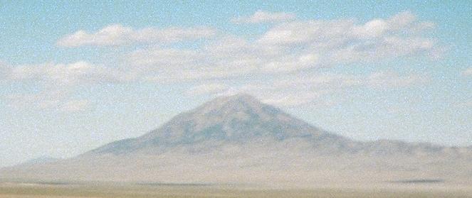 Pilot Peak
Wendover sits on the edge of the Great Salt Desert, and coming over that
last hill was something of a shock. Just beyond the town, the salt flats
begin: flat, featureless, and pale white. It looked like the untouched
part of the canvas God forgot to fill in. Big signs advertised hotels,
restaurants and loose slots. The town sits amongst a jumble of rocky
hills, some covered with decades of graffiti. Wendover is the only town
in Nevada on Mountain Time, so instead of 6:53 it was 5:53 when I stopped
for some gas ($3.95 a gallon).
Pilot Peak
Wendover sits on the edge of the Great Salt Desert, and coming over that
last hill was something of a shock. Just beyond the town, the salt flats
begin: flat, featureless, and pale white. It looked like the untouched
part of the canvas God forgot to fill in. Big signs advertised hotels,
restaurants and loose slots. The town sits amongst a jumble of rocky
hills, some covered with decades of graffiti. Wendover is the only town
in Nevada on Mountain Time, so instead of 6:53 it was 5:53 when I stopped
for some gas ($3.95 a gallon).
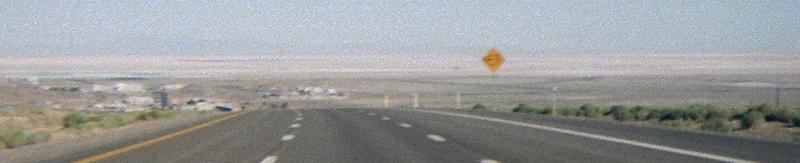 The Great Salt Desert, as seen from Windover
About three miles east of town I hit the desert proper. The famous Bonneville
Speedway rolled past as I headed towards Salt Lake City, 122 miles away.
The landscape was amazingly flat. Off to the north was Floating Island
Mountain, and the heat off the desert created a mirage that made it look
like it was floating. I passed the mysterious Tree of Utah, fenced off
just beside the highway. A police car passed me at high speed, lights flashing.
The interstate runs in almost a perfectly straight line for about 40 miles,
and with a 75 MPH speed limit, they probably get a lot of speeders. I saw
three cop cars in ten minutes. There were also signs warning drivers about
fatigue. The Sun was low in the sky as the highway turned towards the mountains.
It looked like I wouldnt make Salt Lake before sunset. I passed shallow
marshes and wide wet areas. Splashes of forest crept across the mountainsides.
Ahead, the waters of the Great Salt Lake appeared to my left, still and
murky in the fading light.
The Great Salt Desert, as seen from Windover
About three miles east of town I hit the desert proper. The famous Bonneville
Speedway rolled past as I headed towards Salt Lake City, 122 miles away.
The landscape was amazingly flat. Off to the north was Floating Island
Mountain, and the heat off the desert created a mirage that made it look
like it was floating. I passed the mysterious Tree of Utah, fenced off
just beside the highway. A police car passed me at high speed, lights flashing.
The interstate runs in almost a perfectly straight line for about 40 miles,
and with a 75 MPH speed limit, they probably get a lot of speeders. I saw
three cop cars in ten minutes. There were also signs warning drivers about
fatigue. The Sun was low in the sky as the highway turned towards the mountains.
It looked like I wouldnt make Salt Lake before sunset. I passed shallow
marshes and wide wet areas. Splashes of forest crept across the mountainsides.
Ahead, the waters of the Great Salt Lake appeared to my left, still and
murky in the fading light.
I got to Salt Lake City right before 8 PM Mountain Time, right as the
Sun was setting behind me. My plan had been to make a couple of stops in
the city before heading for my selected campsite down near Provo. Of course,
that was before the storms Sunday night and the 3-hour delay in getting
out of Black Rock. I thought I could camp for the night, and then maybe
backtrack to the city before heading on eastward. When I turned onto Interstate
15 south, however, a quick calculation showed it was almost 50 miles
to where Id planned to camp for the night. I was not gonna
make a 100-mile round-trip. So, I pulled off the interstate and headed
downtown.
 |
It was Labor Day. My wife had wanted me to go by the Tabernacle while
I was there. It was closed. In fact, it turns out theres surprisingly
little to do in a Mormon town at 8 PM on a holiday... There was one place
I could visit, though. Way back when Salt Lake hosted the Winter Olympics,
Home Depot had a program where you could have a brick personalized in Olympic
Legacy Plaza, which was being built downtown. I managed to find the plaza
in the middle of a busy business district, inside an area of restored vintage
buildings. The plaza was ringed with the path of custom bricks, which were
divided into sections of about a hundred. I searched section seven, going
back and forth across the dozens of names
and there it was. A brick
personalized with my family name. It was a thrill to see it was part of
downtown Salt Lake, and part of the citys Olympic legacy. |
By then it was dark, and I still had miles to go before I slept. Salt Lake
City is huge; the city spread out in all directions from the interstate.
I came over a hill, and the lights of the city spread all the way to the
horizon
and above. Over the horizon? How were there lights
over--? Oh, wait. Mountains. Right. I had in my notes to turn at Exit
254, but well before that I saw a sign for Utah Lake State Park, so I took
a chance and turned off the highway. It was a short drive through some
residential neighborhoods until I came to the park entrance. Everything
was closed, so I put my camping fee ($20) in the slot. The park was very
dark, but it wasnt long before I found a campsite and pulled in. There
was a covered picnic table, and lit bathrooms about 40 yards away. The
bathrooms were clean and well-kept. I could make out about two or three
other trailers and RVs in the park.
In the darkness, I opened the back hatch and started pulling out all
the stuff Id so haphazardly packed that dusty morning. I locked the bicycle
against a nearby pole. The bike rack was tough enough to connect to the
car in the daylight, so I wasnt even gonna try it in the dark. I pulled
out the tent, spread it out, and got it folded up right. All the time,
the lights in the bathrooms kept going on and off. Was it kids? Axe
murderers? I resolved to keep myself locked in all night. I got my
cot laid out, bundled up against the chill, and quickly fell asleep.
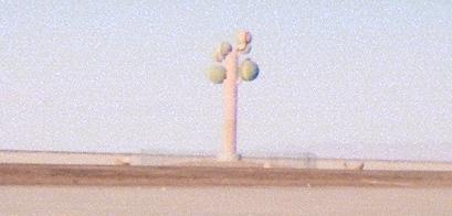 The Tree of Utah, on Interstate 80
|
|
Sunday
|
 Provo to Pueblo
 |