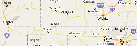
 The Journey East: Pueblo to Broken Arrow
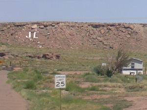
The road out of town was twisty and turny, and I thought I'd lost my way, but soon I was headed out of town. The road ahead pointed about as eastward as you could get. High, feathery clouds danced in the brisk sky. I couldn't find any good music on the radio. I did catch an advertisment for a housing project called the Shire. I wondered if the doors would be round...? I passed lots of trees and grazing lands and small farms. Pueblo must extend far out into the countryside, because I kept passing street signs. A building labeled Excelsior Middle School passed on my right. It was overgrown with grass and looked very closed. I crossed the Huerfano River, and seemed to have finally put Pueblo behind me. Flat, grassy plains stretched away from the highway. A squat, mossy-green ridge rose to the north, but soon even that flattened out. I'd left the Rocky Mountains behind me; the Great Plains beckoned.
Cornfields appeared, fringed with clumps of black-eyed Susans. Just after 9 Mountain Time, I went through Fowler, elevation 4,343 feet. I was facing a tough headwind. A flag on top of a flagpole was almost blown flat out. The highway was a well-maintained 2-lane road, with a wide shoulder. Between the small towns, I managed to get up to 60 MPH-- even faster when I got past rolling roadblocks, like an annoying white semi that seemed to block my path for miles. I finally got around him and zoomed on down the road. The town of Manzanola was a little farming community. There was a big vegetable stand there, one of many I saw alongside the highway. People that had houses next to the highway sold produce out of their front yards.
The town of Rocky Ford greeted me with the bounce of rumble strips in
the road. Many businesses were long closed, like the Corporate Creamery
on the west side of town, but the Tank 'n Tummy convenience store and Don's
Shoes ("For Dad and Lad") were still open for business. I turned off the
highway to take a picture just as the white semi caught up with me. As
it drove on down the road, its engine seemed to cough a frustrated Hrumph!
The westbound highway through Rocky Ford is a one-way street called Swink
Avenue. Swink, Colorado (yes, I was still in Colorado) was just a few miles
down the road. The highway dipped to go under the railroad tracks, a sign
on the road warning "Do Not Enter When Water is in Underpass." At
La Junta, I stopped at a stoplight in front of the new Wal-Mart. A trainload
of coal cars rumbled by. About a mile down the road, I passed the old Wal-Mart,
closed and for sale. The La Junta town square had a gazebo and an old Santa
Fe Railroad caboose. I was 56 miles from Lamar, on the old Santa Fe Trail.
The highway ran straight as an arrow through miles of grasslands. It was
hard to  believe
I was still in Colorado. The road turned through Las Animas, advertised
as "the last home of Kit Carson," although the famous frontiersman actually
lived in nearby Boggsville. There was a statue in the town square. The
old courthouse seemed to still be in use. The high school football team
was the Trojans. Just outside of town, I crossed a lazy creek that turned
out to be the Arkansas River. Down the road, I saw a pasture where sheep,
cattle and llamas cheerfully grazed together.
believe
I was still in Colorado. The road turned through Las Animas, advertised
as "the last home of Kit Carson," although the famous frontiersman actually
lived in nearby Boggsville. There was a statue in the town square. The
old courthouse seemed to still be in use. The high school football team
was the Trojans. Just outside of town, I crossed a lazy creek that turned
out to be the Arkansas River. Down the road, I saw a pasture where sheep,
cattle and llamas cheerfully grazed together.
About 10:40, I made it to Lamar, Colorado. I made a pit stop at the
Valaro Pit Stop, where they sold Spitz brand sunflower seeds, "Sunflower
seeds with a difference." (Their website sells sweatshirts and "Spitz Bags.")
The store sold fishing worms, too. Outside of town, visibility stretched
out for miles in every direction. I kept losing pens, which was really
frustrating when I wanted to write something down while on the road. Traffic
came to a halt at some road construction. Many vehicles lined up behind
me, including a white semi... No, it was a different white semi. Workers
were rebuilding the road. Traffic was 1-lane for a couple of miles. I waved
at the flaggers. Ever since working as a flagger on Exodus, I always wave
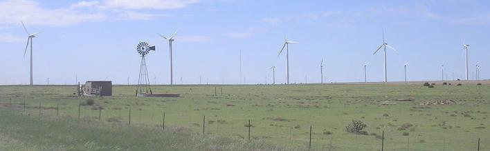
at flaggers. The wind really picked up. Appropriately, wind-powered generators
appeared ahead. The road went through a field of dozens of the huge machines;
horses grazed on the rolling grassland below.
I passed an abandoned house beside the road: no windows, no roof, just
an empty shell. It had been so long since anyone lived there, grass had
overgrown any path leading up to it. Everytime I saw an old house like
that, I wonder, What happened here? Did people live their lives here?
Were they happy? Did they leave because of a personal tragedy, or did opportunity
for a better life draw them away?
I passed the time making up naughty songs. When I got to the Kansas
border, the road was offset with the Colorado road by about 30 feet. Two
narrow, 90-degree turns were necessary to cross the border. I thought,
either some road engineers couldn't read their maps, or Colorado and Kansas
have issues. I was back in the Central Time Zone again, living on
Tulsa time. The only other vehicle I encountered was a blue pickup, which
slammed on its brakes suddenly for no reason, making me jump to avoid rear-ending
him. Jerk. I made it to Ulysses, Kansas, proud home of Olympic vollyball
champion Sarah Noriega. I stopped at a little gas station for a pit stop
(gas was $3.63 a gallon). The rest room key was on a chain with a lug nut.
The girl at the counter said the quickest way to Dodge City was straight
down the road until it linked up with Highway 56. More miles of corn passed,
miles and miles of corn... and sunflowers! Acres of sunflowers, big as
dinner plates. The unexpected bypass meant I missed It got really cloudy.
At the 93/144 interchange, a sign said I was still 50 miles from Dodge
City. It began to rain. In the little town of Montezuma, the main street
through town is Aztec Street. I passed under more wind-powered generators
25 miles from Dodge, but I wasn't gonna let them get me lost again!
  |
 |

At a quarter to seven, it was getting dark. I figured I'd get to Wichita
about 8. In the town of Cunningham, the liquor store advertised "Cold Beer,
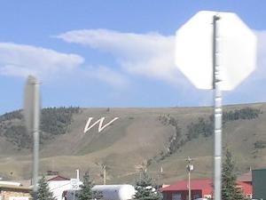
Warm Spirits." I was doing 65 to 70 between the little towns. Kingman,
Kansas was celebrating its 125th anniversary. Signs declared it had "a
past, with a presence." It was drizzling rain when I got to Wichita, shortly
before 8 PM. From there on, it was interstate highways all the way home.
I turned south on I-35, and forgot it was a toll road. It was only $1.60,
but still. At 8:39, I crossed the border into Oklahoma. About 40 minutes
later, I turned east on Highway 412 and paid another toll-- twice
($1.75, and then 75 cents down the road). Wind and rain really started
hammering the van. Oklahoma was getting the remnants of Hurricane Gustav.
The rain let up a little just as I turned off the highway into Broken Arrow.
I rolled up into the driveway right at 11 PM. I was home. Satori and I
had traveled 3,750 miles in 13 days.
 |
 |
 |
 |
 |
 |
 |
 |
| My experiment in drawing versus photographing at Burning man was ...inconclusive.
Sketching people brought compliments and encouragement. However, nobody
gave me any hassles about taking their photograph, either. It may be the
whole online debate was simply a vocal minority making a mountain out of
a molehill. I'm glad I had a chance to get some drawing in; that was fun.
I remain convinced that Burning Man is a public event, and that it's legal
to photograph anyone in a public area. There's thousands of people at Burning
Man, and a big percentage of them are going to take photographs. It may
be easier to not stress out about it and just accept the fact that if you're
at Burning Man, you're probably gonna get your picture taken. People that
don't want to get wet should think twice about jumping in the ocean.
I feel much better about Route 66 these days. It's even kinda fun to
think about. I'm glad I took the time to make those side trips. The next
long trip I take, however, I'm gonna break it down into shorter segments.
Thirteen hours on the road is too much for one day. Within a month of returning
home, gasoline had dropped almost a dollar a gallon.
Disposable cameras are convenient, and you can get some good pictures, but it costs more to have the film developed. Late one night on the playa, it seems Hair of the Dog had a visitor. Some guy showed up and said that his father recently passed away. His father was a bartender, and it was his wish that, after he died, his ashes be scattered in a friendly bar. Remember when I said I collected some dust from the bar in a bottle..? Yeah. I think I came back from Burning Man with some dead guy's ashes in my gear. The bottle now sits in a place of honor on my living room shelf. I call him Uncle Larry.
|
|
|
|
|
|
|
|
|
|
|
|
|
|
|
|
|
|
|
|
|
|
|
|
|
|
|
|
|
|
|
|
|
|
|
|
|
| Links:
Google Maps MSN LiveSearch Maps Dodge City MapQuest Hurricane Gustav Kit Carson Olympian Sarah Noriega Burning Man Official Website Burning Man on Wikipedia Spitz Sunflower Seeds |
 |